Is there any more of the map?
I am having difficulty accessing the maps on daegmorgan. How do you access a RAR file on a PC?
I couldn’t find more.
As to the other question, have you tried to open the file with winrar??
1 Like
So is this stuff just fan made? Like the Sundra region?
I tried with a Winrar. I think I’m using it wrong, because it didn’t work.
Use the 7zip utility instead of winrar.
It opens almost every kind of archive out there.
Yes, it is all fan-made material. The only area covered officially appears, in its entirety, on the 2 maps that come with the revised box set (the expanded Tyr Region map and the Jagged Cliffs Region map) - with the exception of an extended portion of the Silt Sea and a tiny sliver of land on the other side, shown on the map from The Valley of Dust and Fire.
http://www.digitalwanderer.net/darksun/images/athas_map.jpg - a compilation of the above mentioned 2 maps
Strangely, no one has posted a usable version of the VoDaF map that comes up on a google search, except as shown on this compilation map…
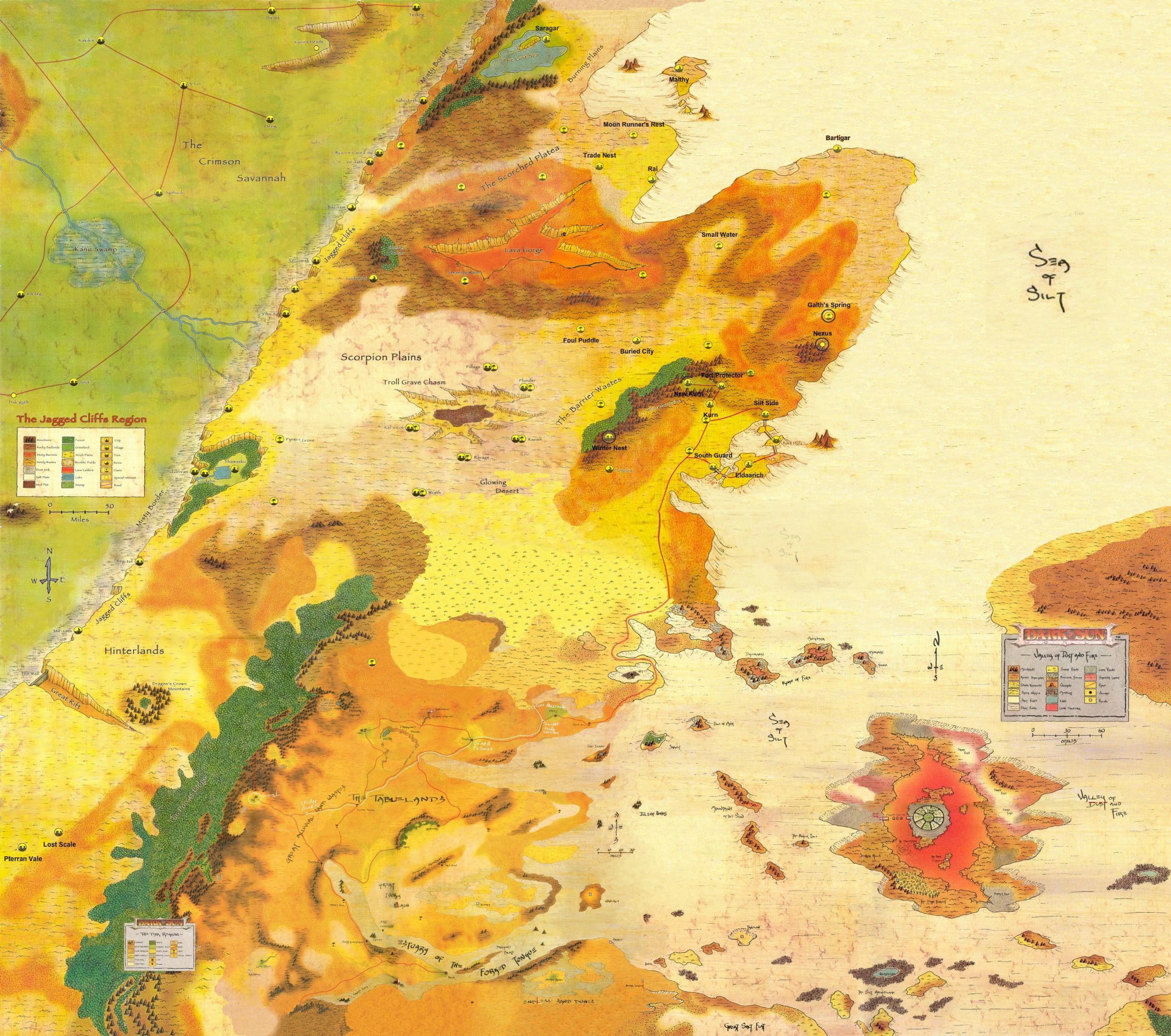
- do note that the northeastern corner is NOT official. Basically, the top half of the extra land mass on the right side of the map and the Silt Sea region directly above it are all unofficial extensions.
3 Likes
Hi All,
The Athasian Cartographer’s Guild site specifically states that you have to click the image thumbnails themselves in order to get .jpg’s of the map sections. If you click the name next to the thumbnail, you will download a .rar of Photoshop CS assets intended for graphic design use. If you do not have photoshop or don’t know how to use it, make sure you get the .jpg’s instead.
-D
That’s good to know.
Yay! They used my little map a made, like almost two decades ago with a simple bit-map program!
1 Like
I dont know how much people really look into it and or think about it, but the hottest temp on Athas isnt that far off from the hottest temp here on earth. I dont remember off the top of my head but for some reason I believe it was only 20 or less degrees fahrenheit. Plus the Tyr region is sitting close to the mid part of the planet what we call the earths equator line. If that is the case then the poles on Athas would still be cold. Now most people may not know this because all they see is desert or silt. However if they were able to live long enough to make the trip they should find that it is really cold at the poles. To be honest if its only 20 degrees fahrenheit then their would still be ice at the poles as well.
All that said, this is one of the reasons why I love Dark Sun more then any other D&D campaign setting, because there is just so much unknown with allows for so much creativity. End the end the DMs and do what they want for the most point and their isn’t much to say that what they decided couldnt be true. I just really love that about this setting.
2 Likes
It’s also mentioned that certain areas not too much further north of Urik (the Glowing Wastes) get extremely cold at night in comparison to the Tablelands proper. Now, that’s without the Ringing Mountains to stop some of the wind that would whip in from the West. I always thought of the map similar to California in RL, with the Ringing Mountains stopping all the moisture on the west side of the range. My thought was that somewhere far to the west off map there would have to be a larger body of water… or a reason for there to be more atmospheric humidity.
1 Like
Amazing work guys in putting this all together!
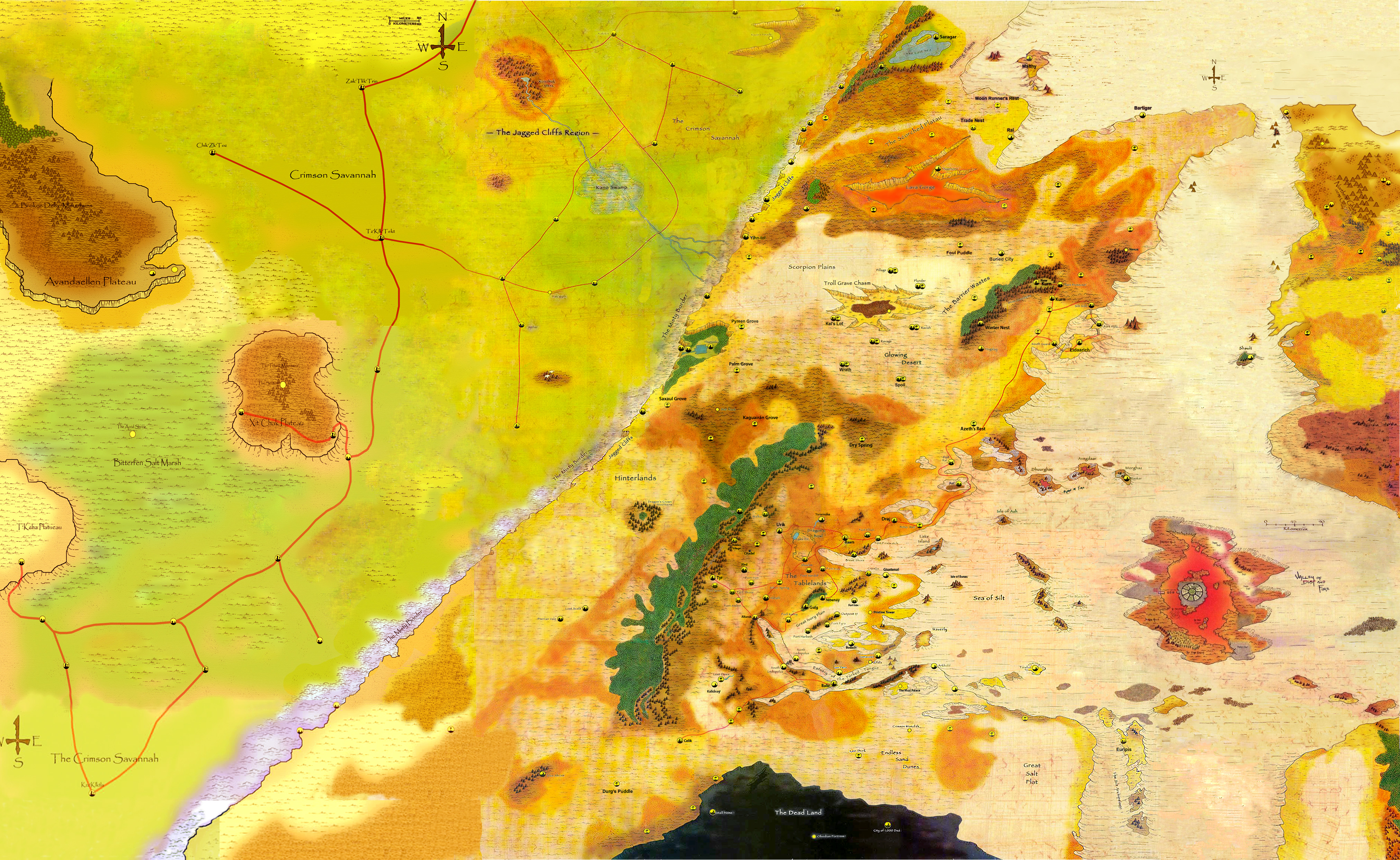
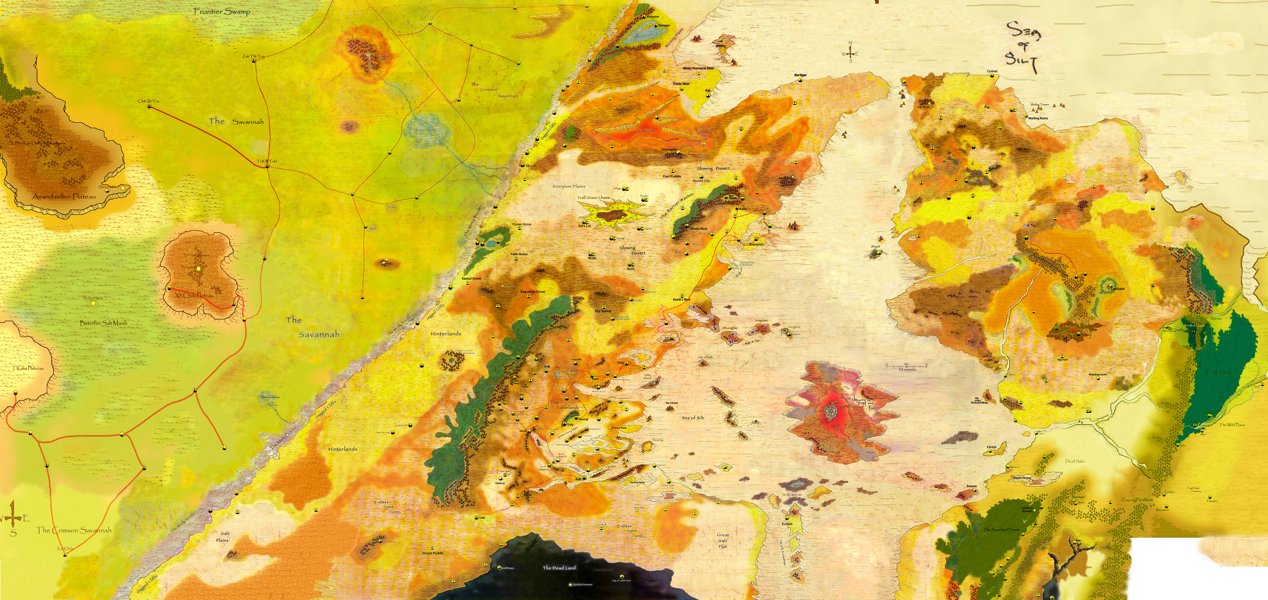
I’ve been spending a lot of time digging for resources out there to fill in the missing gaps from the Athasian Cartographer’s guild, and recently I discovered areas which aren’t featured on his site. I’m looking at using their tools to add new maps to the page.
Anyone know how to get in touch with the guys at the Athasian Cartographer’s Guild so I can add these maps? He isn’t responding to emails…
Hey guys.
I did find this map as well, which improves upon the Digital Wanderer’s map by adding a bit more to the east and west. It also corresponds nicely with just about every other map I’ve seen to date.
Annoyingly I cannot find the original source again. I’ll let you know when I discover it.
3 Likes
Nice, thanks for sharing
2 Likes
[quote=“Garolnemay_Montego, post:25, topic:497”]
Hi everyone and neujacck,
I am the original source  but I just put together all the maps from original resources and maps from Athasian Cartographer’s Guild http://ds.daegmorgan.net/
I’ve expanded to the west and improve a new full version of this one.
Although the work is still in progress.
9 Likes
Great work Garolnemay!
3 Likes
Awesome work. Thank you!
3 Likes
This is amazing Jhonny! Thank you again.
I was about to comment that you should add in The Sundered Regions, but then I noticed that you already did. I was expecting them to be smaller than they are. I can see how tricky it must’ve been to get those two maps reconciled. Well played!
If only we could get access to the code at http://www.digitalwanderer.net/darksun/ and update the map he’s using with this one…
2 Likes
The Sundered Regions are there but very spread out. Cool none the less.
2 Likes
That’s really great work, and just the kind of thing I was hoping could be organized in an earlier thread I started. I wonder if we can expand this to include the rest of the continent. I think the first priority would be to include all of the kingdoms mentioned in the deadlands document that was recently released, which would involve expanding the map southward.
What program(s) are you using?
2 Likes