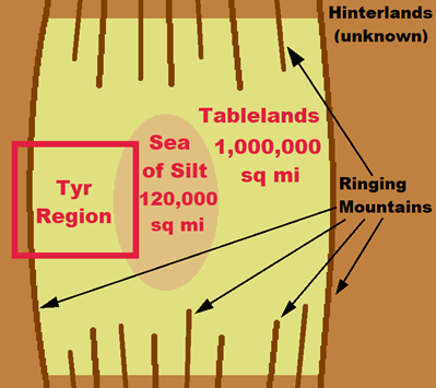
This is a fine piece of work from a commenter at EnWorld. Here is a map from the essay reproduced below. Make sure you read the entire essay.

This is a fine piece of work from a commenter at EnWorld. Here is a map from the essay reproduced below. Make sure you read the entire essay.

I thought that essay was very informative and hence also evocative.
I still don’t really understand this map, as all maps I know only put the Ringing Mountains to the West side inbetween the Tyr region and the Hinterlands/Jagged Cliffs.
Or is it that the Wanderer’s description in the original box set gives the impression of an encompassing mountain range?
That’s correct. The geography was retconned in later products. When I saw the updated geography years after reading the original boxed set, I was very confused as well.
I guess this is also bc I originally came to the setting quite late. I first bought the revised setting and only in later years worked my way back getting older stuff.
Note to self: read that early Wanderer again!
So much got retconned (or maybe just plain forgotten) after the initial release. The ringing mountains no longer ringed anything, the empty hinterlands suddenly got filled with vast savannahs with plenty of water and thriving with life, the cities across the rest of the tablelands all disappeared. Its a shame really. The world as described initially was intriguing.
Yes. I want to know more about the Tablelands Sorcerer Monarch that is titled magnate, but this SM was retconned out of existence.
Which ones do you mean Andrew?
The original boxed set mentioned there were (unnamed) city-states to both the north and south of the Tyr region that the others traded with. And there was a mention of a SK who had the title of Magnate, which none of the known SKs had.
And it was heavily implied, if not outright stated, that people lived across ball the Tablelands as seen in the map above of how the world was initially described as looking.
2nd note to self to really get that read again. I can’t remember this at all.
But where would such cities lie then? Further away than Draj up north and south of Balic, Kalidnay, and Celik or?
They are minor references, easily missed.
As to where exactly they would be, just north or south is all it said. The geography changed when they extended the initial map.
Including The Wandered allowed them to change anything and just say it was an unreliable narrator. It’s a great read and is interesting to think about what could have been.
How about this theme. A dual classed wizard/psion can become a Sorcerer Monarch, and many do. These nascent Sorcerer Monarchs stake out a place in a tiny oasis and build their city over time.
That’s as good a premise as any to plugin your converted Pathfinder Kingmaker for a campaign I’d say 
That is more or less what the Wanderer speculated on in his journal. He made mention that most (but not all) SMs were defilers, which meant that somewhere out there beyond the Tyr region there were prserver/psionist SMs. We got Oronis, sort of, be he wouldn’t have know of him. So others maybe.
But he also specifically says that he felt that was how Draj got started - Tec was a minor defiler who with his followers settled the mudflats of Draj, built it into a city and in time became a sorcerer-king. That sounds a much better story than champion of Rajaat personally.
Here is an interesting concept that might link the two concepts together? Maybe the “ribbed” effect of the northern and southern Ringing Mountains were caused from the curvature? The image also places the Sea of Silt in the “middle” of the “known”/explored area described by the Wanderer.
Just an idea.
Original post - Alt-Athas, in progress
Image - Alt-Athas Ringed Tablelands Full Res by AdmundfortGeographer on DeviantArt