World Size Does Matter

It could just be a disk.

Not a disk. Not flat. (Contrary to what Uncle Tontor believed) Notice language of “once held that”

Dragon Kings pg 6. In an elven legend:

“The wyrms deposited Uncle Tontor unceremoniously on the underside of Athas. (Elven folklore once held that Athas is flat.)”

Also please see Marauders of Nibenay and Nibenay’s orrery.

4 Likes

So, to run some calculations and build on what you’ve wrote.

We know the size of the 4e tablelands map to be 519.33 miles east to west (based on some other members’ calculations) and 261 miles north to south (by my own measurement laying the map out in CAD). For the continent to be 9 squares tall, that would make it about 2349 miles north to south (one state shy of coast to cost east to west through the middle of the USA).

So, how much bigger/smaller should the planetary view be? Or even better, can we calculate the diameter from this planetary view?

athasmap500

How many square miles is one of the rectangles?

Or what is a rectangle’s height and width.

We also assume the planet is roughly the same high as it is wide. Roughly uniform radius.

A bit larger than the state of Colorado given that one of the more central tiles is the Tyr region and stuff from the original CS.

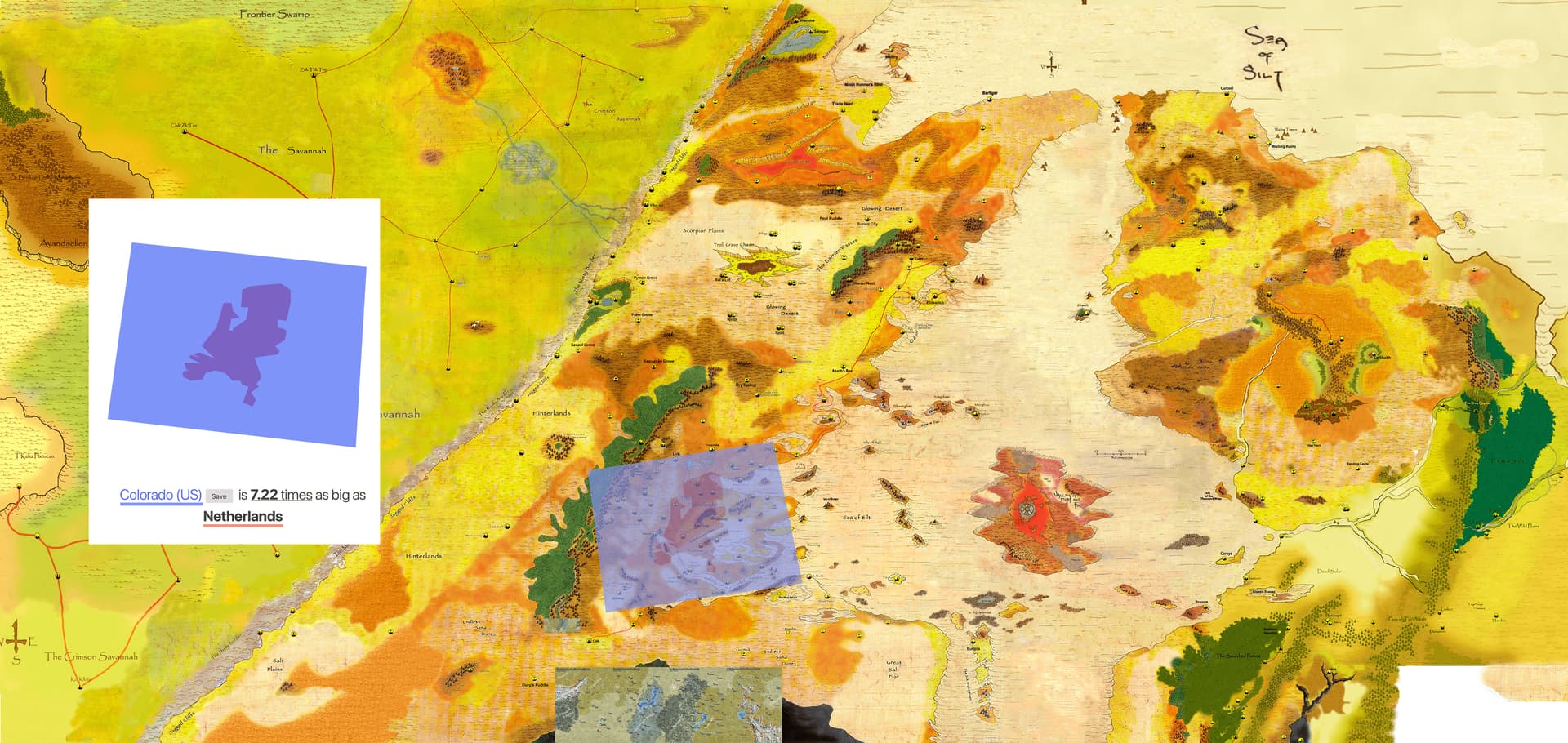
I actually toyed with one of the maps uploaded earlier in one of @neujack 's topics on the world map and put in a size comparison for my own reference with the outlines of Colorado state and my own country (the Netherlands).

Remember this is on a sphere trying to be projected onto a rectangle. Which is why Greenland looks so big on a Mercator map when really it is much smaller. The rectangles at the extreme north and south actually contain less square miles in the area.

Circumference of the earth is 24,900 miles. Assuming roughly spherical planet then a line traveling from North Pole to South Pole would be half that. 12,450 miles

Colorado is 280 high x 380 wide ~106,000 sq miles.

  • Which is what you say the area on the map are about the size.

Total surface area / area of Colorado

200,000,000/100,000

Means you need about 2000 squares total.

Top down
12,450 / 280 = 44.5 rectangles high

total needed / high
2000 / 44.5 = 44.9 total rectangles wide about.
(One way to calc width, the one below is better)

Width
Total circumference / width of Colorado is 24900 / 380 = 66.5 total rectangles at the equator

There’s really probably more rectangles needed than the 2000. Due to all the “wasted”area at the poles

So I have 44 high by 66 wide which gives 2.904 total. You have 24 total already mapped.

1 Like

All those “spheres” are 2 dimensional in that picture.

1 Like

For those interested in mapping an entire planet this video is worth watching

2 Likes

A long time ago I printed out an old hex graph full world map of Athas, cut it up, taped it together and it made a ball. It was great for figuring out the larger world. Somebody eventually made a more traditional flat earth type map which I turned into a globe (https://drive.google.com/file/d/1XVdBkd5pD3oDeyDRY8iJVAXC5DlkBeLm/view?usp=sharing) but the poles are a bit screwy due to the flat map.

For a long time I’ve used a different size of the world than most. Horizontally if you multiply the 2e maps by 2.5 you end up with a world roughly the size of Earth (24,750 miles for Athas to Earth’s 24,901). Vertically though you need to multiple by 3 (actually a little more, but 3 is easier to multiple of the fly) to get things to fit correctly.

It makes the Tyr region 750,000 square miles, a little smaller than Mexico. That easy trade run suddenly takes a lot longer and becomes a lot more dangerous both from a survival standpoint and the chances of being intercepted far from help.

7 Likes

The 2.5 multiplication is exactly what the 4E map did.

As said above, the 4e map is 519.33 miles wide by 261 miles tall, according to the scale measurement seen on the image…

In square miles, that comes out to 135,545. Between New Mexico and Montana in size.

The Athasian Cartographer’s guild is 9 tiles x 8 tiles wide.

2 Likes

Here is another useful piece of information for making maps on Earth-sized planets:

A degree of latitude, one degree north or south, is about the same distance anywhere, about 69 miles (111 kilometers). But a degree of longitude, one degree east or west, is a different distance at different points on the globe.

At the equator, a degree of longitude is the same as a degree of latitude, about 69 miles. But it decreases as you move closer to the north or south pole.

69 miles * 360 = 24,840 miles total circumference.

The image above represents about 7.53 degrees.

I think most people agree that area of the Tyr Region takes place near the equator where day lengths will be roughly the same throughout the year and there is little impact from axial tilt. Which is probably minimal but still there, besides the mention of High Sun and Low Sun solstices, there doesn’t seem to be much effect from it.

3 Likes

As a bit of a follow up to this…

on a Mercator map it is broken into squares / rectangles by degrees of longitude and latitude of 15 degrees wide by 15 degrees high.

The whole world view map is 12 “squares” high by 24 “squares” wide.

Which means each “square” along or near the equator is showing about 1035 miles wide by 1035 high. (69 x 15 = 1035)

Or about one million square miles. 1035 x 1035 = 1,071,225)

1 Like

All in, based on all the numbers we’re throwing around, it looks like the entire continent shown in the Athansian Cartographer’s Guild globe map seems to more accurately represent 1/4 of the world, rather than half. That is of course we assume the same planet size as Earth.

Of course you could make a denser core and achieve the same gravity with a smaller planet. That would make all this a bit easier, as we could then just try to shoe-horn in their old mercator map.

Here is my version, compiled from all map data I’ve found so far:

And here’s a closer view of the continent containing the Table Lands, with all the maps I could find superimposed onto it. That red splotch in the middle of the Silt Sea in the middle of the continent is the Valley of Dust and Fire, and that tiny arc of green in the middle is the Forest Ridge. The Dead Lands content to the south of the Tablelands is based upon the working beta version map we’re using for the project now.

Here’s the bugger-- this entire continent is roughly the combined size of North and Central America according to the calculations presented here…

3 Likes

Is it possible to double all the distances in each direction? Or does that break stuff?

I thought of that.

That does really mess with every encounter in every adventure though.

Other alternatives could be:

Change to a smaller size planet. (Find a way to keep Earth gravity, and other factor as previously discussed. if that matters to you

Or

Increase the amount of “ocean/silt” between continents. Especially above or below the main continent.

Or

Abandon that map. That map doesn’t look to be the scale of a true Mercator map. If the width of it matched an earth Mercator there would be more map to the top and bottom.

1 Like

I like that map, but it’s not canon. So I would prefer to maintain a planet the size of Earth and create a new map.

I, and this is personal taste and completely based on head-canon, would also move the main continent to the south hemisphere.
Then, the Dead Lands would cover also the south pole and if you go north from the mapped area, the temperature increases as you move towards the equator.
To me this helps to explain why people lives in the Tyr Region: because the adjacent areas are not suitable for supporting life.
They can only move east, where you have the Kreen Empire, or west, where you have the silt sea and had the Dragon. This leaves the way open to find new city-states on the west shore of the silt sea.

1 Like

Knowing the sun rises in the east and sets in the west On Athas, when a character is looking at the sun around noon where do you envision the sun to be? Southern sky, northern sky or directly overhead. This will also determine the hemisphere you are in. If you are in the northern hemisphere the sun will be to the south.

Also moons wax from right side to left side in when viewed from the northern hemisphere.and wax from left to right in the Southern Hemisphere. If that matters, this is the same convention the merchant calendar program uses for moon phases.

(Even the iPhone uses this convention despite it being different for people below the equator. When searching thru emojis type wax or wane and you’ll see what I mean. It has a northern hemisphere bias)

I’ve tried to determine where the continent is based on that info and haven’t been able to find language that mentions the sun or moons in the southern or northern sky. I also haven’t been able to pair an image of the moon with words saying it was waxing or waning.

2 Likes