All those “spheres” are 2 dimensional in that picture.
1 Like
For those interested in mapping an entire planet this video is worth watching

2 Likes
A long time ago I printed out an old hex graph full world map of Athas, cut it up, taped it together and it made a ball. It was great for figuring out the larger world. Somebody eventually made a more traditional flat earth type map which I turned into a globe (https://drive.google.com/file/d/1XVdBkd5pD3oDeyDRY8iJVAXC5DlkBeLm/view?usp=sharing) but the poles are a bit screwy due to the flat map.
For a long time I’ve used a different size of the world than most. Horizontally if you multiply the 2e maps by 2.5 you end up with a world roughly the size of Earth (24,750 miles for Athas to Earth’s 24,901). Vertically though you need to multiple by 3 (actually a little more, but 3 is easier to multiple of the fly) to get things to fit correctly.
It makes the Tyr region 750,000 square miles, a little smaller than Mexico. That easy trade run suddenly takes a lot longer and becomes a lot more dangerous both from a survival standpoint and the chances of being intercepted far from help.
7 Likes
The 2.5 multiplication is exactly what the 4E map did.
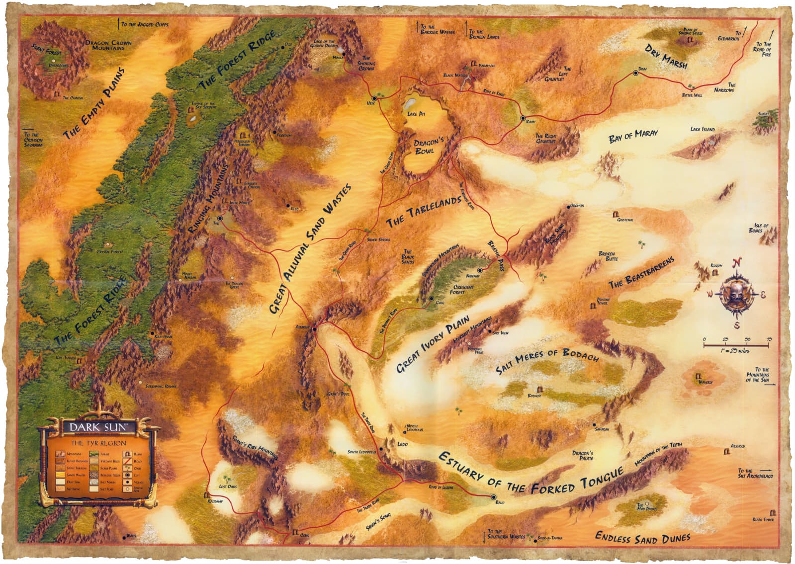
As said above, the 4e map is 519.33 miles wide by 261 miles tall, according to the scale measurement seen on the image…
In square miles, that comes out to 135,545. Between New Mexico and Montana in size.
The Athasian Cartographer’s guild is 9 tiles x 8 tiles wide.
2 Likes
Here is another useful piece of information for making maps on Earth-sized planets:
A degree of latitude, one degree north or south, is about the same distance anywhere, about 69 miles (111 kilometers). But a degree of longitude, one degree east or west, is a different distance at different points on the globe.
At the equator, a degree of longitude is the same as a degree of latitude, about 69 miles. But it decreases as you move closer to the north or south pole.
69 miles * 360 = 24,840 miles total circumference.
The image above represents about 7.53 degrees.
I think most people agree that area of the Tyr Region takes place near the equator where day lengths will be roughly the same throughout the year and there is little impact from axial tilt. Which is probably minimal but still there, besides the mention of High Sun and Low Sun solstices, there doesn’t seem to be much effect from it.
3 Likes
As a bit of a follow up to this…
on a Mercator map it is broken into squares / rectangles by degrees of longitude and latitude of 15 degrees wide by 15 degrees high.
The whole world view map is 12 “squares” high by 24 “squares” wide.
Which means each “square” along or near the equator is showing about 1035 miles wide by 1035 high. (69 x 15 = 1035)
Or about one million square miles. 1035 x 1035 = 1,071,225)
1 Like
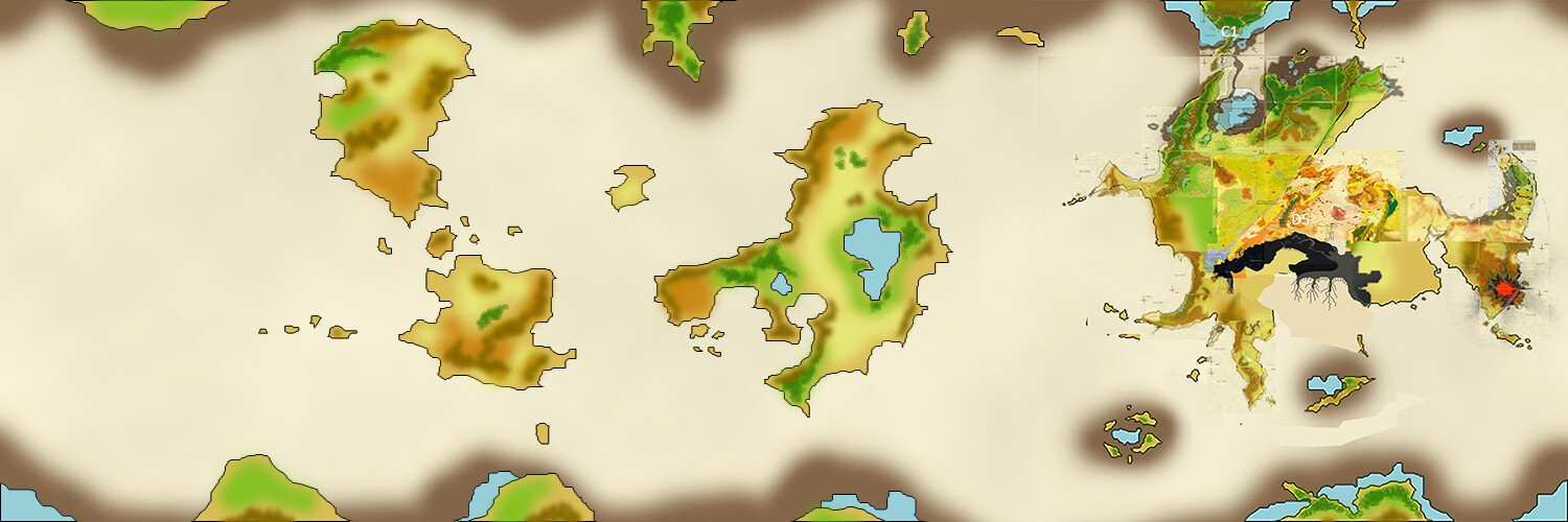
All in, based on all the numbers we’re throwing around, it looks like the entire continent shown in the Athansian Cartographer’s Guild globe map seems to more accurately represent 1/4 of the world, rather than half. That is of course we assume the same planet size as Earth.
Of course you could make a denser core and achieve the same gravity with a smaller planet. That would make all this a bit easier, as we could then just try to shoe-horn in their old mercator map.
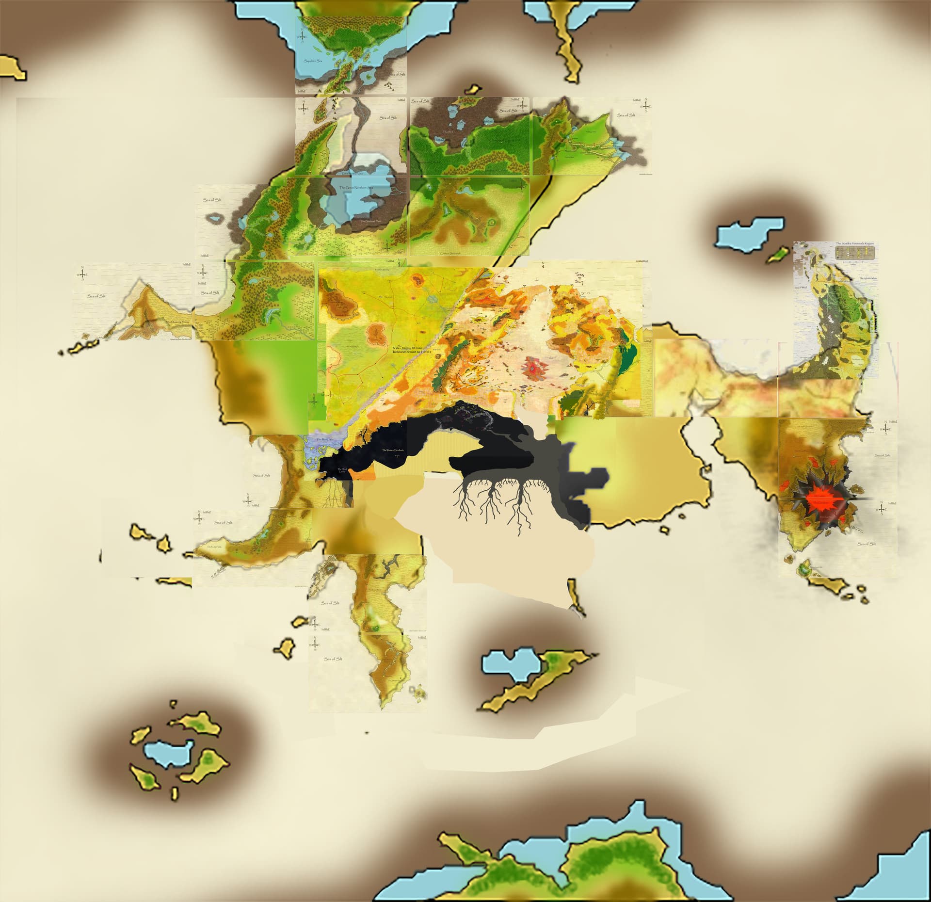
Here is my version, compiled from all map data I’ve found so far:
And here’s a closer view of the continent containing the Table Lands, with all the maps I could find superimposed onto it. That red splotch in the middle of the Silt Sea in the middle of the continent is the Valley of Dust and Fire, and that tiny arc of green in the middle is the Forest Ridge. The Dead Lands content to the south of the Tablelands is based upon the working beta version map we’re using for the project now.
Here’s the bugger-- this entire continent is roughly the combined size of North and Central America according to the calculations presented here…
3 Likes
Is it possible to double all the distances in each direction? Or does that break stuff?
I thought of that.
That does really mess with every encounter in every adventure though.
Other alternatives could be:
Change to a smaller size planet. (Find a way to keep Earth gravity, and other factor as previously discussed. if that matters to you
Or
Increase the amount of “ocean/silt” between continents. Especially above or below the main continent.
Or
Abandon that map. That map doesn’t look to be the scale of a true Mercator map. If the width of it matched an earth Mercator there would be more map to the top and bottom.
1 Like
I like that map, but it’s not canon. So I would prefer to maintain a planet the size of Earth and create a new map.
I, and this is personal taste and completely based on head-canon, would also move the main continent to the south hemisphere.
Then, the Dead Lands would cover also the south pole and if you go north from the mapped area, the temperature increases as you move towards the equator.
To me this helps to explain why people lives in the Tyr Region: because the adjacent areas are not suitable for supporting life.
They can only move east, where you have the Kreen Empire, or west, where you have the silt sea and had the Dragon. This leaves the way open to find new city-states on the west shore of the silt sea.
1 Like
Knowing the sun rises in the east and sets in the west On Athas, when a character is looking at the sun around noon where do you envision the sun to be? Southern sky, northern sky or directly overhead. This will also determine the hemisphere you are in. If you are in the northern hemisphere the sun will be to the south.
Also moons wax from right side to left side in when viewed from the northern hemisphere.and wax from left to right in the Southern Hemisphere. If that matters, this is the same convention the merchant calendar program uses for moon phases.
(Even the iPhone uses this convention despite it being different for people below the equator. When searching thru emojis type wax or wane and you’ll see what I mean. It has a northern hemisphere bias)
I’ve tried to determine where the continent is based on that info and haven’t been able to find language that mentions the sun or moons in the southern or northern sky. I also haven’t been able to pair an image of the moon with words saying it was waxing or waning.
2 Likes
I’m happy to work with someone else’s new measurements for a map. This map isn’t really mine anyway, and while I understand why they didn’t make much in the way of additional land masses, I’d like there to be more.
How about this: I could tweak that original map above to be just the northern hemisphere, and then I think that would double everything in size.
As for moving this to the southern hemisphere- the reason why it doesn’t work to put the Dead Lands so close to the south pole is because the Dead Lands are scorching hot during the day, so they have “normal” daylight/evening hours, and similar seasons to the tablelands. it’s position of being closer to the equator works for the write-up.
Envision it as North Africa but with obsidian instead of sand. That would mean the Tablelands have a climate not unlike the drier parts of the mediterranean area (ie Central Spain, Turkey, Syria, and the Slavic regions), which sounds about right.
1 Like
TL:DR The Dead Lands are not larger than the Kreen Empire.
There have been multiple maps for the southern continent floating around recently, depicting the Dead Lands as covering roughly half the continent containing the Tablelands.
The team that is working on finishing the Dead Lands (Secrets of the Dead Lands, Faces, and the adventures-incl The Emissary) has decided to make some adjustments to the continental map in advance of their releases.
This is being done to accomplish at least these two goals:
-stop everyone from unnecessarily speculating about the size/whereabouts of the Dead Lands (according to the official project specs from athas.org) and provides the project team with stability / time to finish the project.
-provide everyone with a rough landscape beyond the official Dead Lands setting expansion (and Sundered Lands work) to fill up all you like.
With this we hope to accommodate the community with much needed clarity around the Dead Lands.
Due to that we will crosspost this in several relevant ongoing discussions, sorry for that.
Unless WoTC is planning a 5e Dark Sun, which does not look promising given their recent wokeness, no one knows the exact mapping of the planet. Whatever you do is in essence a fan service and not canon. Que the canon fascists yelling at anyone doing something cool… “that’s not canon…”
1 Like
You can also get the effect of a hotter area by decreasing the elevation. Death Valley, California has an elevation of 282 ft below sea level and has some of the hottest temps on earth. Dallol, Ethiopia also has some of the hottest temps at 430 ft below sea level.
1 Like
What is the city or land feature farthest from Tyr? Do we know how far it is in both north-south and east- west components?
If using a Mercator style map I would propose putting Tyr at the 0 degree longitude line. Move it up and down from there as needed.
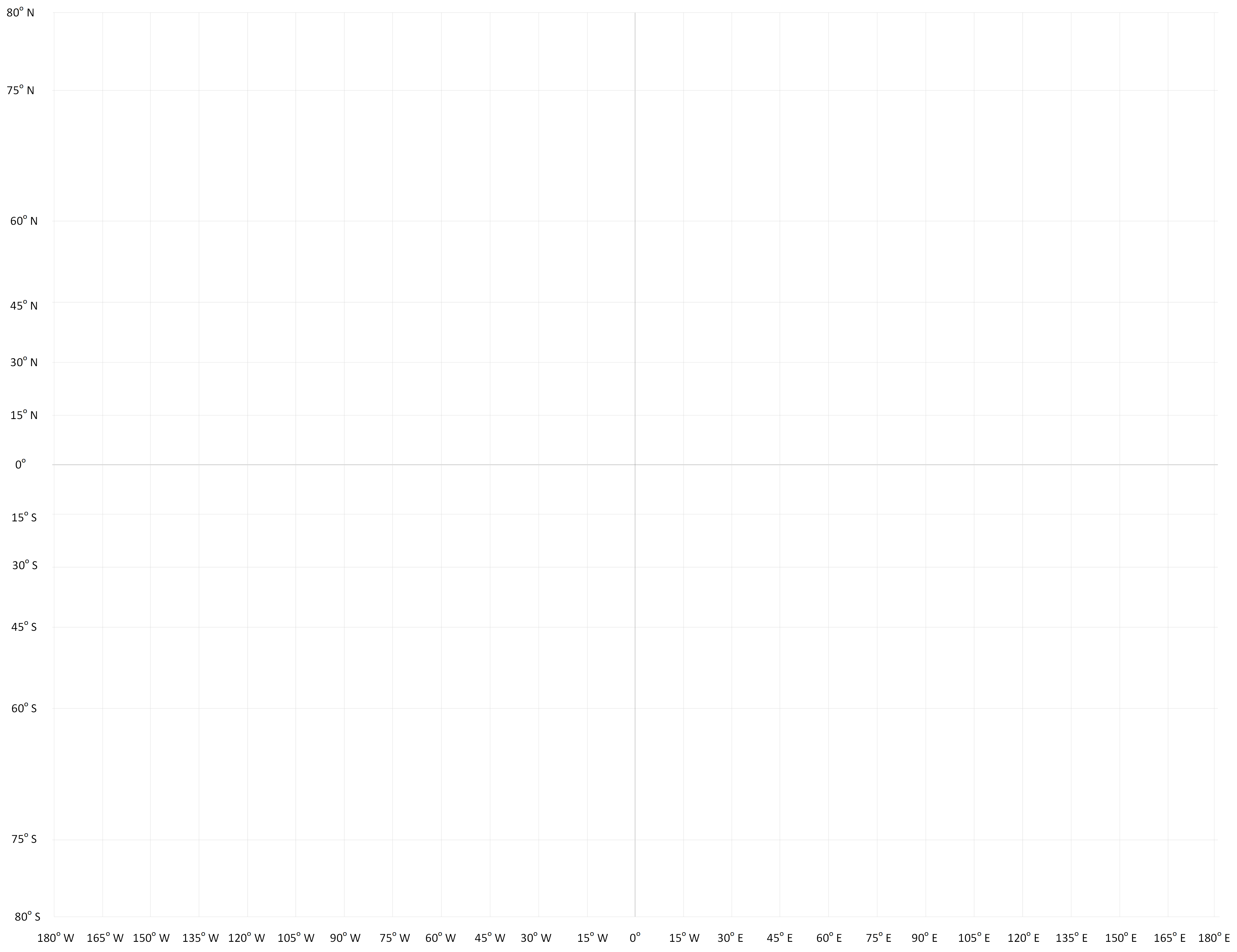
I created a blank Mercator map based off a couple I pulled from the web. Nor sure how useful it will be for anyone wanting to use it. This one ignores everything above 80 degrees north or south. It would be interesting to see how the mapped world fits on it. Or does this already exits somewhere?
1 Like
Wow! I never thought about this and the kind of implications of being in the south hemysphere, probably because I’m also biased.
Then my idea shouldn’t probably be used as a canon explanation. However I think I would continue to use it in my campaigns, as for me it’s more important to have a solid explanation on why the Tyr Region is the most inhabited part of the world than the way the moons wax.
Maybe then it shouldn’t be in the south pole, but at least covering part of the the soouthern hemysphere. In any case, I suppose that a giant mass of obsidian, without any kind of vegetation, would always be hotter than any other surrounding place.
As I see it, the main problem to have the Tyr Region on the equator is that it is the hotter region of the world. If you go south or north from there, the climate should be milder. People naturally would have moved to any colder place they could find. The way to avoid it is to set some kind of boundaries that prevented the people to move.
We have three known boundaries:
- West: the Kreen Empire.
- East: the Silt Sea and the Dragon. Now maybe open to some kind of naval exploration of the east coast of the silt sea.
- South: the Dead Lands.
But we don’t have any real northern boundary. There isn’t any kind of reference in the books that explain why people has not colonized the lands beyond Saragar. And if the climate is milder, they should have.
Have you looked at the sheer inhospitable terrain to the North of the Tyr region?
It’s either the traderoute which comes with it’s own mighty risks of being very close to the Silt and being well-known to the bandit states or the desert which goes on for a long long time.