I’ve searched and so far cannot find any info on the elevation of the Forest Ridge. I assume it is at a higher elevation than the surrounding areas (other than the Ringing Mountains of course) and has access to moisture up where it’s cooler which is partially why it was able to stay alive (as well as being protected by the halfling tribes and other deadly flora/fauna). There are likely streams / small rivers up in the mountains also that must dwindle and dry up once at lower elevations (in the past they ran further but now have become dried river beds/gullies/ravines). Any thoughts on this are very welcome.
1 Like
They are high enough to cause altitude sickness. So, the mountains are, at least, 8,000 feet.
2 Likes
Read the info in the original box set it lays out all you really need to know about the geography of the rining mountains and the forest ridge. The eastern side of the mountains (facing the tablelands) is relatively barren particularly as you get near the ridge, but once you crest the mountains the Western Slope is covered in jungles. Personally I would assume that they start somewhere below the highest peaks, but they can’t be far from the ridgeline. It’s called the forest ridge for a reason.
From the forest ridge entry in OBS:
" As the traveler crests the summit of the Ringing Mountains, he sees what is perhaps the strangest
sight on Athas, and one that will assuredly take his breath away. Below him, a jungle of tall fir and
birch trees covers the steep slopes of the high mountains, with a thick undergrowth of rhododendron
and mountain bamboo. It stretches north and south along the spine of the mountains as far as the eye
can see. This is the legendary Forest Ridge, the paradise at the top of the world."
" Although the mountains on this side of the summit are as steep as those on the eastern side, the
footing is much less treacherous…"
" Even in this paradise, you still will suffer from mountain-sickness. The slightest exertion still fatigues you and your head still pounds, but at least the thick canopy of the jungle provides some shelter from the sun."
3 Likes
as a gross simplification I’d say it’s probably something like this.
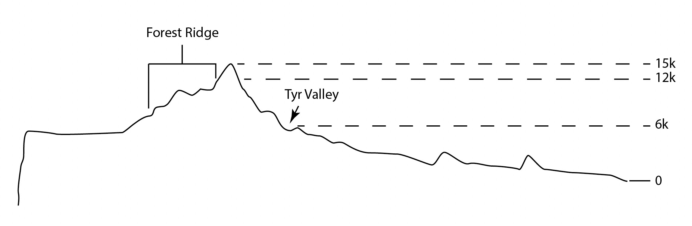
But trying to convey 3D elevation detail in a 2D cross section is hard.
7 Likes
This is the way I view it as well.
1 Like
About the moisture and vegetation of the Forest Ridge, we can assume that the Tyr region is warmer than the Hinterlands, with winds going from the Hinterlands to the Tyr region. The air loses its humidity (residual humidity from the swamps at the base of the Jagged Cliffs ?) when rising in altitude to cross the Ringing mountains (Foehn wind - Wikipedia).
There is probably a Foehn Wind when air rises from the Crimson Savannah towards the Hinterlands, explaining the vertical jungles of the Jagged cliffs with a first loss of moisture, and then a second Foehn Wind when the air rises to get to the Tablelands, losing its residual water.
Nice 2D cross section Ruhl-Thaun_Sage, by the way.
3 Likes
The tree-line is around 8,000’: secondly, it won’t be jungle growing there, but pines and firs. Either the Forest-Ridge is a lot lower, or, the author* thought Pine-Trees = Jungle.
*The Wanderer.
1 Like
The Forest Ridge is most likely based off of the Manti-La Sal National Forest which is in eastern utah and lines up with the Tyr Region maps. The highest peak is about 12k ft.
1 Like