I will use if for a campaign based in the Pallas trading post, which will include a lot of interactions with the other factions of the valley, and exploration of the valley itself.
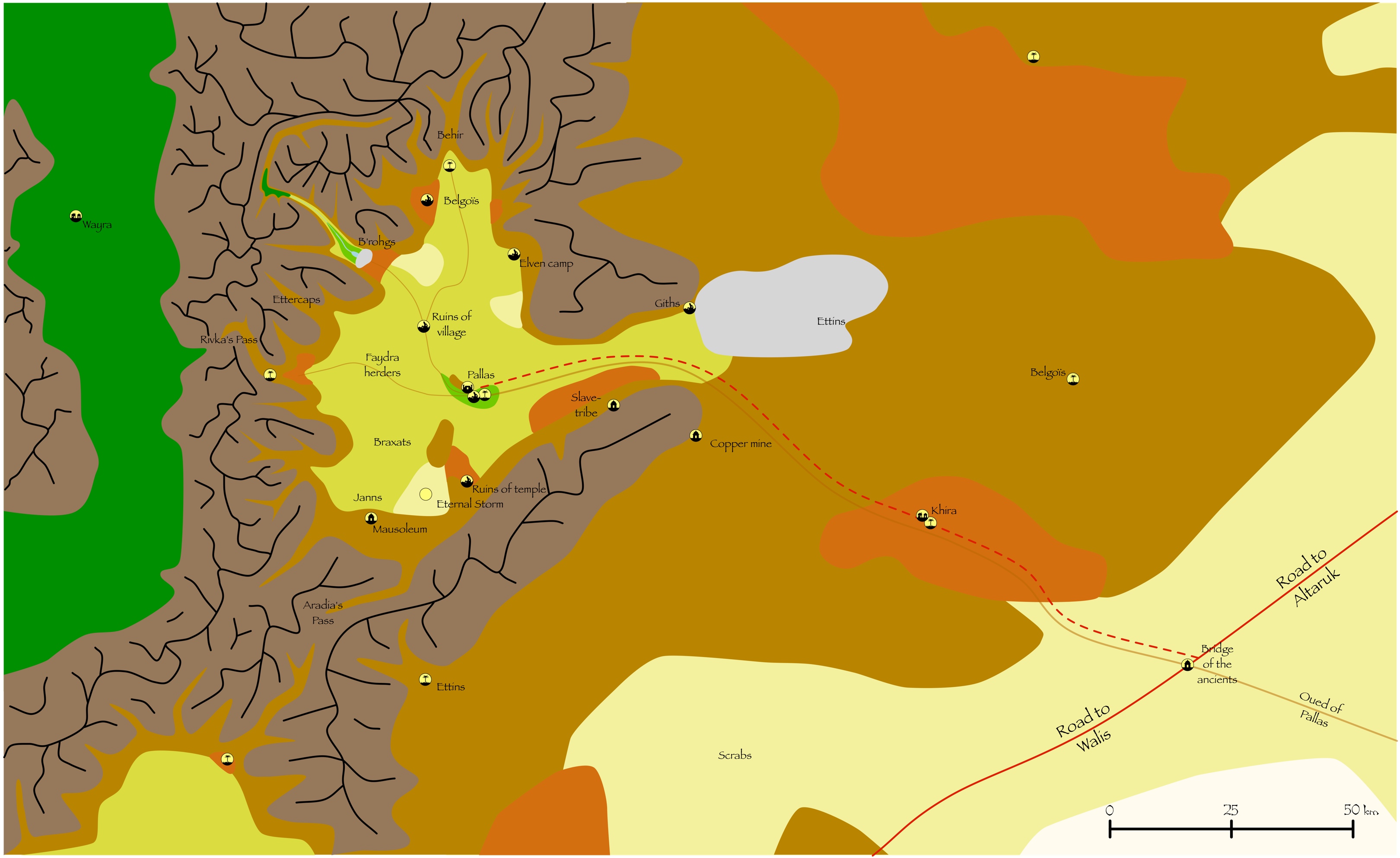
The forest in the valley in the north (where there is a small river and a quite large lake) is protected by an athasian treant. The Rivka’s Pass allows commerce with the halfling clans on the other side of the Ringing Moutains, while Aradia’s Pass make it possible to go to the other valley south.
The black lines are depicting the crests of the mountain ranges.
Double checking my map of the Tyr region I actually spotted some valleys in the south ringing mountains that perfectly fit what you’re doing, so that’s a really nice touch. I’m definitely curious on what factions will be having the spotlight here. This seems primarily focused on the dynamic between independent settlements and the dune trader houses.
However I am curious if the regions marked with monsters will be seeing them as an active force in the valley or more as local predators. For appropriate major monsters for this valley I’ll give tareks a shout out as they are a mountain dwelling intelligent race that seem quite at home in this region.
It is indeed based on the map of the Tyr region. The valley south of the Pallas Valley is the one at the same level as the village of Walis. I juste detailed a bit more the area and the different factions.
Tareks could indeed be one of the factions of the valley. But at the same time I was wondering which factions could be active in the valley to the south, so why not the tareks ?
The real active “factions” are the herders, the giths, the halflings (with a renegade group causing trouble with the other halflings clans based in the village of Wayra, and impeding commerce), the belgois (a small clan of 10), the elves and the slave-tribe.
Herders and elves will be neutral, commercing with the trading post but trying to cheat.
Giths will be the “immediate” threat.
Slave-tribe will be agressive, but with careful approach and negotiation could be turned into ally.
The ones operating the copper mine will be trading more and more with the village of Khira instead of the trading post of Pallas, with opportunities to change that.
And the other monsters will be threats during the exploration of the valley.
If there is a copper mine going on here, having an outsider power (Celik, dune traders, or perhaps even Balic) that has access to tin could make for an interesting dynamic. After all a decent supply of bronze is invaluable and could motivate just about anyone to get involved. Of course this all depends on how involved you want enterprising powers intruding on the region.
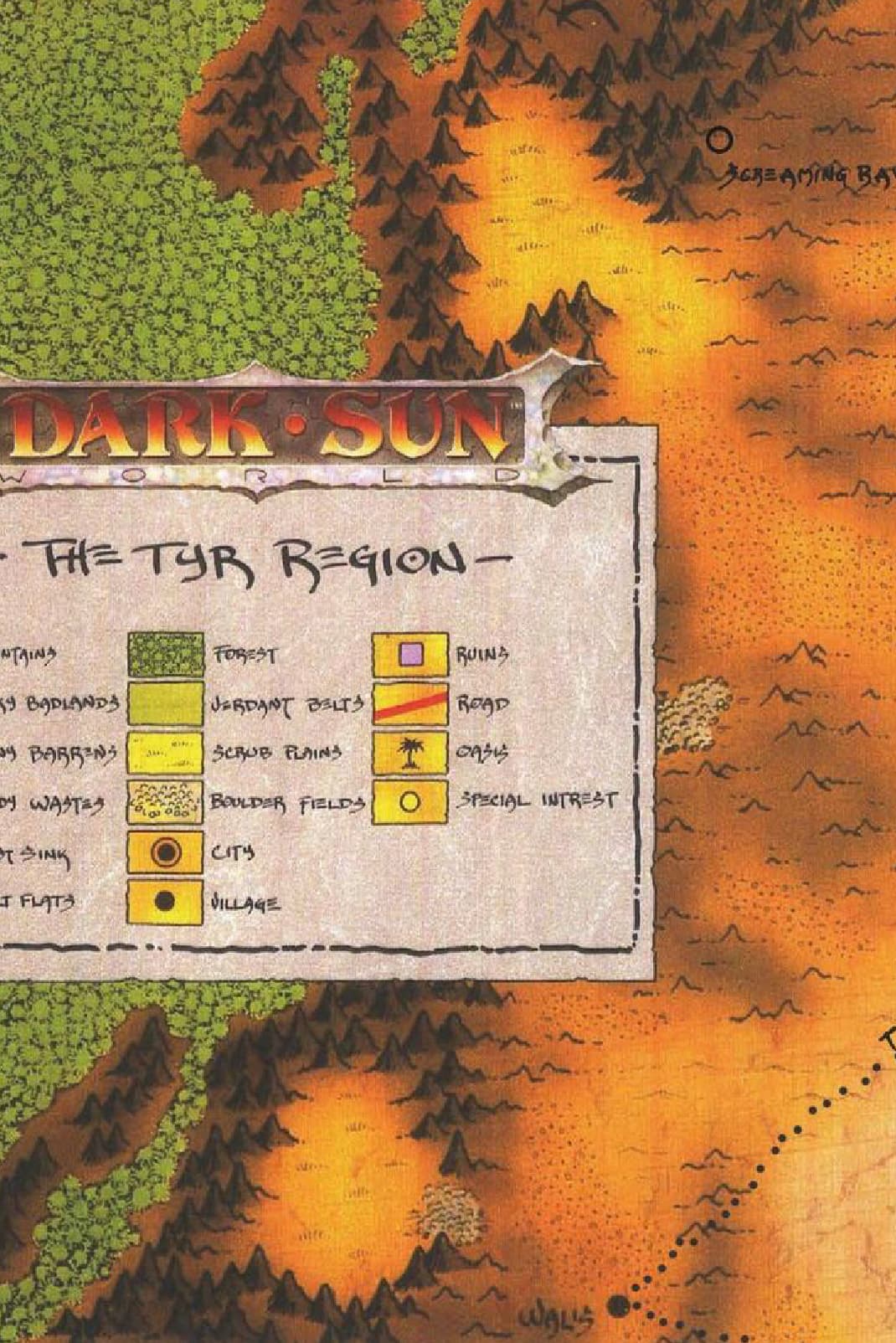
Is this scaled to 2e or 4e map size, (it looks like it’s probably 4e scaling)
Also is the location of this the valley found on the map shown here, or the one that could be hidden behind the legend? It seems to be the latter. I hadn’t previously noticed that there was a boulder field poking out of the edge of the legend. In other places along the eastern side of the Ringing Mountains those boulder fields are strongly associated with scrub valleys. Is that what the grey is on your map? An indication of boulder field?
It is close to the 4e scaling, which I found more logical considering the height of the Ringing Mountains and compared to the Piedmont in Italy for a similar geographic region.
The location of the valley is behind the legend (it can be seen on the black and white hex reverse side of the original map, and in color on the cloth map of the revised campaign setting https://www.enworld.org/attachments/f1018979-0b4b-4519-8b62-7236bcd71d81-jpeg.258296/).
The grey area is indeed a boulder field, which does not block the main entrance to the valley as in the southern valley.
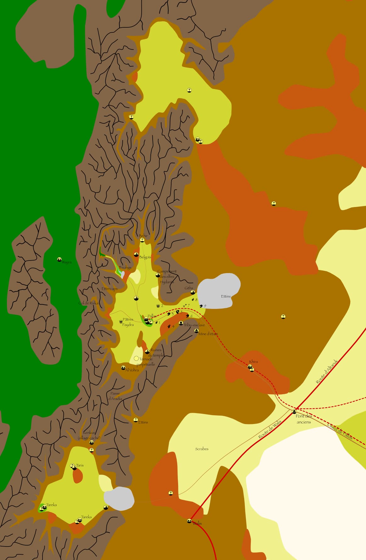
A larger view of the area with the two adjacent valleys is included below.
Clever idea!!! I never once thought of creating my own my of the area hidden by the legend: Good work!
I looks like you used an Adode-type program with Athasian Cartographer’s symbols, or maybe you cropped your own.
I like the mountain’s ridges; from a geography point-of-view, ridges define the borders of states and territories.
If you have a program that can do layers, make each type of terrain it’s own layer, then, you can had a specific-effect to it if you want to add stuff to your map.
Thanks for your comment, it is appreciated !
I used a vector-based program, Affinity Designer, and reproduced the symbols of the villages and ruins of the revised boxed set. This program can manage layers, and add some effects to them. Maybe I will refine it in the future.
Mountain ridges are indeed important for the borders especially, in my opinion, in the ringing mountains: it explains why it is difficult to access the Forest Ridge, and why there are so few exchanges with the halflings.
In the campaign I am running, I used the suggestion of Star-Sage and replaced the copper mine by a tin mine. Much more valuable than copper (200 cp by the pound (refined) compared to 50 cp by the pound for copper, which makes the value of bronze 75 cp by the pound). And it can provide a better dynamic for the interactions between the merchants and other power factions.
The Walis gold mine with its 6 Tomblador defilers is not so far away !
To further expand the region, I made an alteration to Fort Adros (the fort between Altaruk and Walis on the Gold Road) : it is a merchant fort run by both the Tomblador and the Wavir trading houses to defend this invaluable access to the gold mine of Walis run by the Tomblador and the Pallas Valley outpost run by the Wavir with its tin supplies (a bit like Altaruk is co-run by the Wavir, Rees and Tomblador merchant houses). The chief of the fort, Lambaros, is a powerful fire cleric (13th level), unsympathetic and cruel, but very effective at repelling the bandits, looters and monsters of the region. The Wavir and Tomblador caravans have to resupply the fort on their way to Wallis or Pallas, as this fort as no commercial ressources to trade, it is only a military outpost.
I’ve also added the Khira Oasis with a large village on the path between the Gold Road and the Pallas Valley. This fortified village tends a large palm grove with orange trees, banana trees, pomegranate trees and apple trees. The lowest strata of the valley is used for growing vegetables, feed and cereals.
It is a supply and exchange area for the herders and nomads of the region. They sell some goods to the Wavir, and the Tomblador use it as a supply point for Walis : both for fresh food, and from time to time a defiler comes incognito for the material components needed for their spells and experiments.