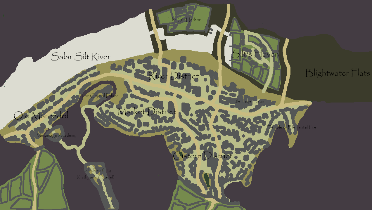
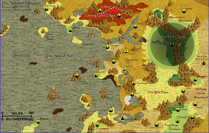
What you did do is a fantastic jumpoff point, nonetheless, I particularly like the concept of the Metamages and their possible ties to gith 
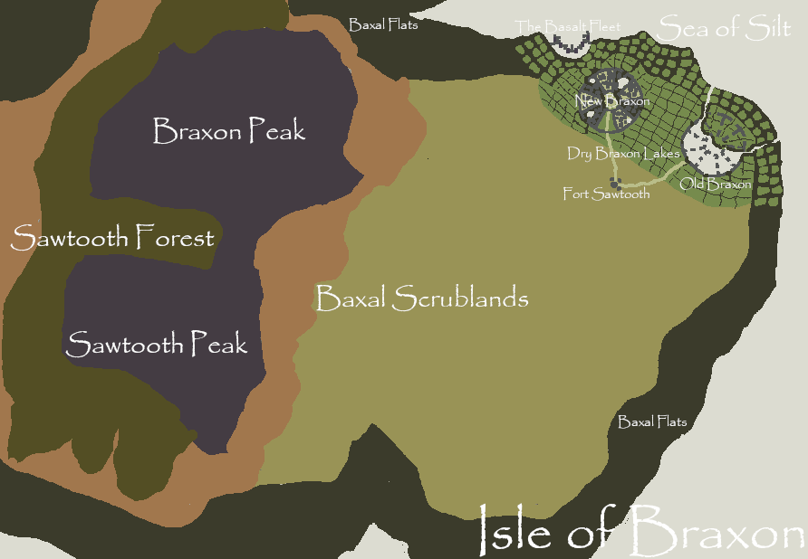
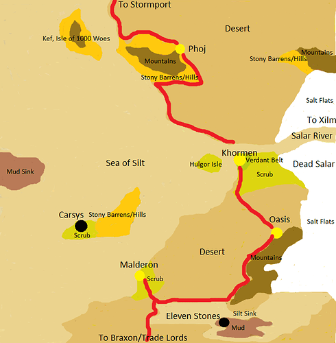
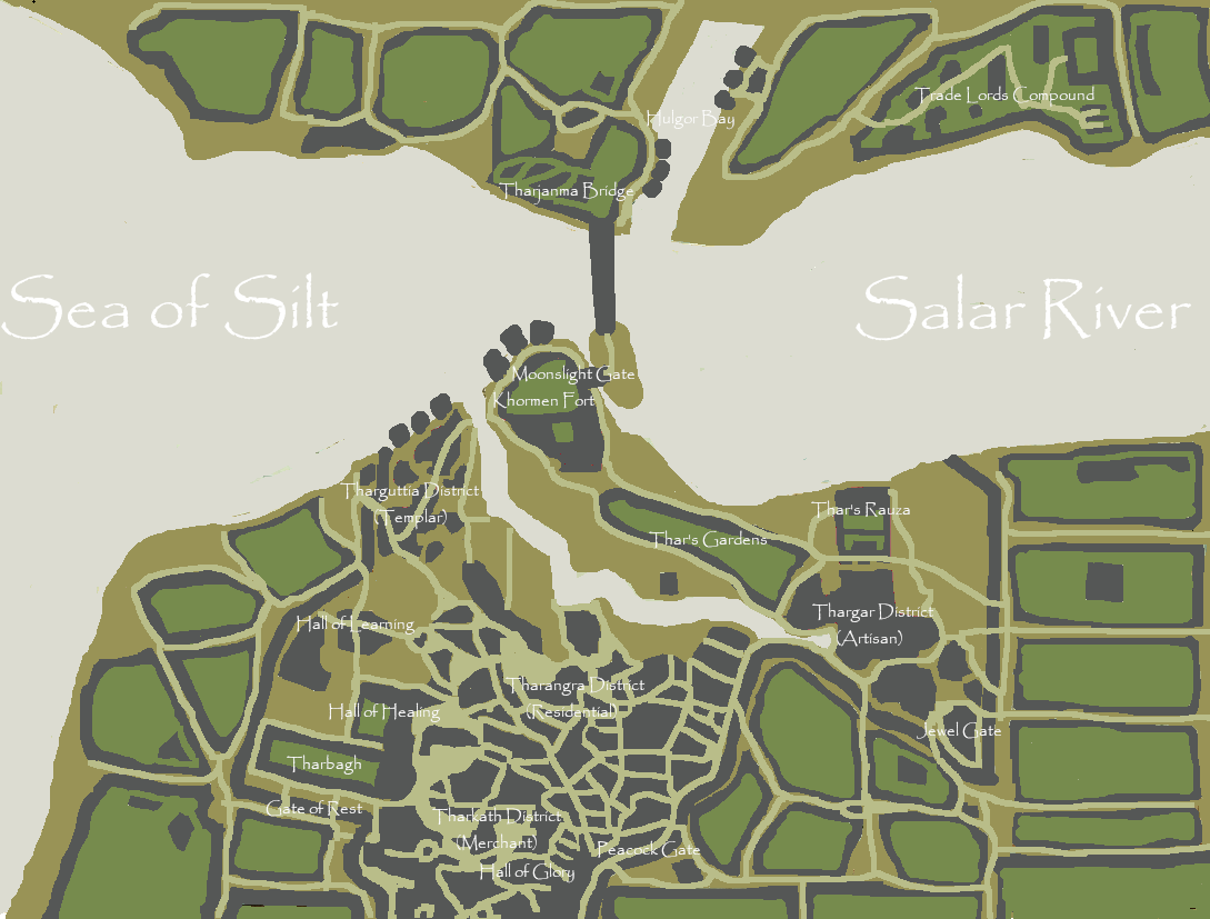
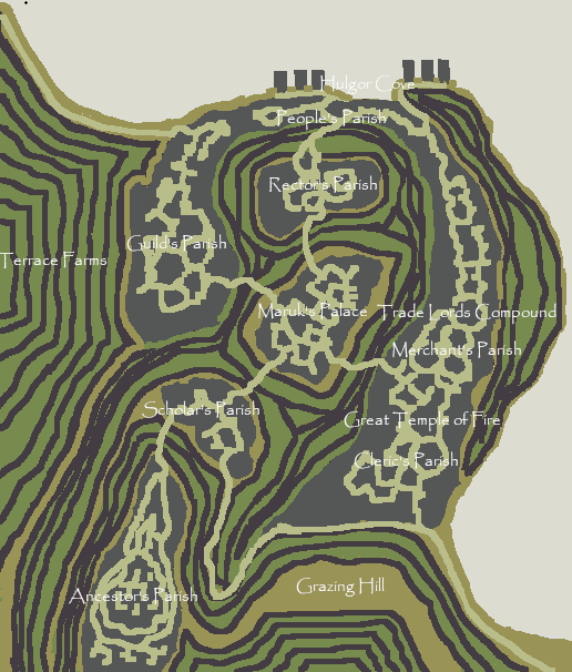
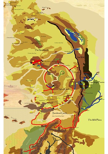
Back in 2020 in the height of covid lockdown I had made a number of tentative maps based on the Sundered Regions, while using Garolnemay_Montego’s composite as additional inspiration (as they were trying to combine the “Anattan Wastes” with "Sundered Region), these are outdated to even my own headcanon of the region but I’m still using them for inspiration.
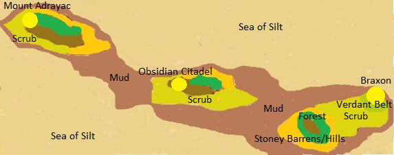
Braxon and its islands would be lightly forested and connected to the same reef/island system as the Baxal Shoal (from Pirsm Pentad). The city was an ancient colony of the island-nation of Ebe (Ur-Draxa, per 4E) and resettled by Draxans as an eastern outpost. The Lord Mariner flees here after the fall of Ur Draxa with undead and turns the settlement into their new base. Much smaller than Sysane’s take, maybe a few thousand people.
(Ignore Carsys, at the time of making I didn’t know it was in the Trembling Plains)
Khormen (map based on Agra, India) was a Green Age city founded on the Equatorial Continent, Anattan, by either the people of Ebe, or possibly the ancestors of the Draj. While destroyed during the Green Age, it was reoccupied by Draxan as an eastern outpost, partially restored, and surviving scattered communities on the mainland slowly assimilated either forcibly or willingly. Following Ur-Draxa’s fall Amandia and the surviving Dragon Warriors fled east, initially staying on one of the island peaks in the sea of silt before taking Khormen as their own. She’s rallied many surviving draxans to her banner, and unlike the lord mariner is more interested in carving out her own kingdom than waiting for the Dragon to return. Larger than braxon but still relatively small, a few thousand people.
Shorn (from Sharn, to avoid Eberron comparisons)
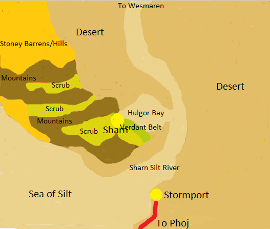
Shorn was another city of the green age proto-draxans or draj who occupied the coast of Anattan, and was utterly destroyed during the cleansing wars, leaving a jumble of shattered towers and rubble. During this ancient battle, a powerful “proto-champion” was betrayed and sealed away under the ruins by their second-in-command, a fire priest named Maruk, who was rendered immortal by a pact with a powerful fire elemental lord. Maruk’s followers were joined by bands of survivors from the Cleansing Wars who found the ruins, which were still relatively fertile due geographic isolation, and the settlement emerged as the only known settlement in the region for centuries, until Borys came. It was too small to extract a levy, so Borys took it as a Draxan outpost (Maruk was in little position to complain) and allowed Maruk to serve as a priest of the “Holy Dragon.” Post fall of Ur-Draxa, the small city has seen a flood of Draxan Refugees, and Maruk is now free to forge their own destiny. The largest of the three settlements, but still only a population in the few thousands.
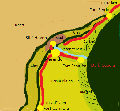
(Based on Sevnica, Slovenia, the capital of the province real-world Marendol is located in)
Marendol was another Green Age Ebe/Draj settlement that, while devastated, remained relatively fertile as the broad river it was located on shriveled into a mud-flat. It was resettled by various human survivor groups as well as some Elves of the hidden kingdom of Faye’Loryn, and rapidly came into conflict with the Illithids of the Dark Cupola, who were relatives of the Illthiids of Oshul, of the Hiramin Highlands in the far southwest. Over the centuries the remote town has been locked in perpetual war, turning much of its own lands around the Cupola into a scorched no-mans-land, surviving mostly thanks to the powerful “Meta-Mages” a band of evil psion/defilers who rule as a totalitarian Magocracy. As the town was too small to extract a levy from, Borys took it as a draxan outpost, but the mind flayers were too petty a threat to bother with (and in truth, they probably amused and fascinated the dragon of Tyr), with the Metamages ruling in his name. Post Prism Pentad Marendol has lost the limited Draxan support it recieved and is now on its own against resurgent Illithids from the Cupola. However, it has recieved aid from a mysterious new benefactor- Githyanki whom survived the events of Black Spine and were stranded on Athas, and are eager to enact vengeance on Illithids while securing their own power base.
Great stuff! Had Sharn and its monarch totally devoid being beholden to Borys and the Obsidian Citadel being the only survivor of Ur-Draxa, but love what you filled in for the SR.
Thank you! 
I figured Maruk might have fallen under at least the influence of the Dragon (we know he pretty much had run of the Planet) but perhaps their fire pact and isolation enabled them to hide the city, and least for a while. I’m planning to incorporate the Sundra Peninsula as the other side of the continent, by just making the “Dragon” in that area Borys. In my mad efforts to reconcile as much as possible with Brax and Brian’s stuff, the volcanic area from Brian’s map, the Cauldron, is the former homeland of the ancient Kurnans, a green age kingdom known as Kel Tas, which was destroyed by either a random meteorite or volcanic eruption. Due to the isolation and distance from Ur-Draxa Borys reserved it as his private experiment ground, with the “Basalt Tower” being his base in the area. The Republic of Suna is not some hidden enclave- its a dual-sided experiment by Borys to preserve a little slice of the green age and, should the Sorcerer-Monarchs fail to meet the levy, he has a backup reserve. Suna will either be a sellout Avangion who has decided working Borys is for the “greater good” or just an elaborate ruse.
Dry rivers should be called Wadis, imo.
going by the map I used as a base (the combined Sundered Regions/Anattan Wastes map posted in the Worlds Maps of Athas thread) they’re actually rivers of silt which is a cool concept, presumably (magical?) silt flowing like water. There’s one in the dead lands as well, made of “black silt” (pulverized obsidian).
Fun fact: the Hebrew name for wadie is Nahal-Achzav, which literally means “disappointing stream/brook”
Why? Why just go with the Arabic term? Why not Arroyo (Spanish), Donga (Afrikaans, derived from Zulu)?
Come to think of it, none of the terms we’re talking about are particularly accurate as they all refer to dry river beds that seasonally flood with water. Arguably that’s not the case on Athas except in certain areas (the Ringing Mountains for example) - there’s no seasonal flood.
The term “river” has been used to describe moving bodies non-water substances in plenty of fantasy literature. Lava, blood, fire, sand, all come to mind.
The average Athasian wouldn’t even remember a time when rivers of water existed, never mind what a dried up one would be called.
The Wadi in my campaign flooded in Spring once. It made for a cool tense scenario while the players were using it as a highway. Especially since the walls of the wadi are canyon like, only a few exits and entrances.
Incredibly late comment, but you wouldn’t happen to have written any more stuff about the Sundered Regions, would you, Sysane? I’ve found a few more pages archived in the Dark Sun Public Share folder, like about metamages, H’rohg, and Darqwyn.
Other than whats there and this thread no.
Happy to answer questions though.
In my campaign your Dark Copula was created for rhul halfling circle of druids to protect their home from the Sun changes and the dragon magic and other catastrophic events. Forest of Souls is a forest with wild life-shaped creatures and creations and the places (cities and villages) are rhul not elven here.
For me has a lot more sense the green forest masses on DS belong to halflings the halflings who fled the Brown Tide and other events.
One question i have is how the illithids in the dark copula act if some psurlons manage to found them? I read that psurlons and illthids are somewhat related. Notice that psurlons are adapted to athasian sun unlike illithids
I imagine they had conflict at somepoint in the past during the height of the Illithid Empire. If they encountered each other in present day Athas, I’d think the psurlons would actively seek to undermine the illithid of the Cupola and bring about its destruction.
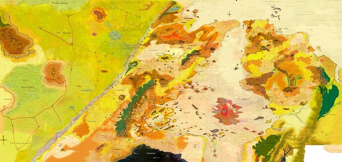
Returning to the Sundered Region or Anattan continent writ-large, attached below are a series of some of the best maps I have found from the community that cover at least the western half of this mysterious continent. I do this to help us understand this continent better, and to compare, contrast, and consider possibilities for what we would like to see in this vast land mass. I lead with what I think is one of the very best extant maps, one which covers most of this eastern continent, and for that matter much of the Dark Sun world:
Compared to other similar maps, it reduces that often far too enormous footprint of the Dead Lands, which too often dominates the southern portions of our maps to distasteful degree. I would want to play in Dark Sun, and not in the Dead Lands campaign. Even in this map, the Dead Lands is as large as the Tablelands. That is plenty of room to play in. We do not need it as a super-continental block of obsidian that blocks off Athas to the southern Silt Ocean.
I believe that Sysane and Darkinterloper are some of the key creative talents behind this Eastern Continent, which by our usual loose consensus I believe we are calling Anattan, after the city of Anatta which lies to the west of the so-called Burning Forest in the southern part of the continent. The few who know of this great land mass in the Tyr Region might call it that as we in the West in the real world call the eastern part of the world “Asia”, who in some ancient past originally referred only to a comparatively small portion of western Anatolia.
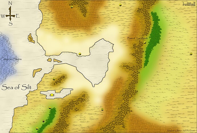
However, compare the map above with the solid work from the famous work of Brian Sanchez and the Athasian Cartography project. It is much starker, cleaner, and empty. Do we prefer that the Anattan continent be so sparse? Indeed, I prefer it to be more desolate than the Tablelands:
Lastly, compared Darkhelm to the newer DarkSunRising [who was behind this great project?] version of the continent. A tasteful conflation, I would say. This map provides more space for silt sea culture, and is also considerably more empty and forlorn, though surely he would say there is room for expansion and further detail. I have often favored this map in many respects.
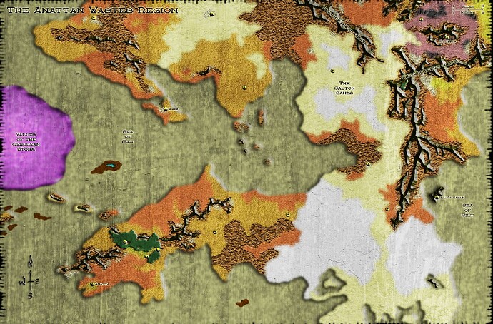
I also include here Sysane’s work from many years ago. I believe he has stated he has taken a step back from this map, and I am cautious with it, but that said I believe it has floated for years, and has seeded our minds and imagination with many concepts. Darinterloper’s work stems I think in large part from this original map, and though I prefer to progress to a less cluttered and more forlorn vision of Anatta, I believe we should keep an ear to Sysane’s early work on the continent:
And of course we should include Darkinterloper’s work on the western portion of the continent, which includes the “Spiral Lands”, which I am to take it is a polite lift from another fantasy writer named Mike Fleming. I quite like the map in many ways, and am considering how best to incorporate his thoughtful exploration of the region.
I proffer these maps in a single post to re-launch here a discussion of some of the core themes of this continent. I admit I currently lack the skills to draft such skillfully rendered maps, especially maps in the manner of the original boxed set, which I would prefer. But even if I did, I am not yet confident enough to understand what we would prefer here or not, and as has long been our tradition here at Athas.org, I would like to try to include many of the best ideas from over the years. And obviously, to each his own version of Athas, but we have I think benefited from a strong tone of loose consensus about many of these matters. We tend to appreciate and respect the creators of Hither Athas, and this is why we have given the nod of general approval to the Athasian Cartographer Guild. But for the purposes of play, some more work is needed, I would argue, and some concepts need further maturation / development.
In an effort to help organize our lines of interest, here are some key cities/locations that in my opinion need further definition, or a strong revision from Sysane’s early brief details, which perhaps need some further development:
City of Anatta
City of Braxon
City of Calhurst
City of Elramyth
City of Haadragor
City of Khormen
City of Phoj (I think this city will not exist in my campaign)
City of Shorn
City of Stormport
Republic of Suna (not on these maps, but on the Sundra peninsula on the NE of the continent)
-note, the snippet about Suna that Grummore found discovered is inchoate and underwhelming; I propose we consider another description of the Republic of Suna that makes more sense
City of Tradelords (I have disliked the city, as much as anything as for its name)
And as far as locations, development is needed for:
Eleven Stones
The Scorched Forest
The Forest of Souls
Island of a Thousand Woes
The history and culture of the region also needs much attention. I speculate the cultural bases of Nibenay and Raam come from the southern portion of this continent in antiquity, and further speculate that some of these cities, such as Anatta and Khormen have moderated elements of this culture base. I also speculate that the Yuan-ti cult originated in the southern portion of the continent, originally a great swamp land called the Ghat, which is no more. But much else is needed to make the continent more playable. Especially challenging is the influence of Draxan culture, whether it be proto-Draxans from the Eben culture, Draxans who have somehow migrated from Ur-Draxa while it stood (and any empire they enjoyed), and refugee Draxans from the super-city’s collapse, must especially the surviving Dead Lords, such as the Lord Mariner. Also, the presence of advanced beings, and especially any other “dragon” that might exist on this continent, for Nok stated that “many” dragons existed throughout the world.
I shall offer what I develop as I go, but as always I of course request your input, your previous work, and any criticisms and ideas to help build this mysterious and fascinating part of the world.
Sysane, in my campaign I fear I am leaning towards scrappung the Dark Cupula. In my thoughts on it, I just prefer such exotic non-Athasian monsters not have such a strong and large impact on the Anattan continent.
As you designed it so long ago, are you pleased with the design and placement of this unique realm? Or in a wider scope, what might you have changed now regarding the Sundered Region, apart from your original, early vision for this side of Athas?
Darkinterloper, Sysane, in your maps of the Sundered Region in and around Khormen, especially in the city itself, the name “Thar” is incessantly repeated.
Who or what was “Thar”? Why is he near omnipresent in Khormen? I believe it was originally presented in Sysane’s map of the region from 20 years ago, so perhaps this is a question for Sysane.
The only thing about the Cupola I’d change is its size. Reducing to slightly less than half its current radius.
A question for Darkinterloper to address. Thar isn’t something I developed,
