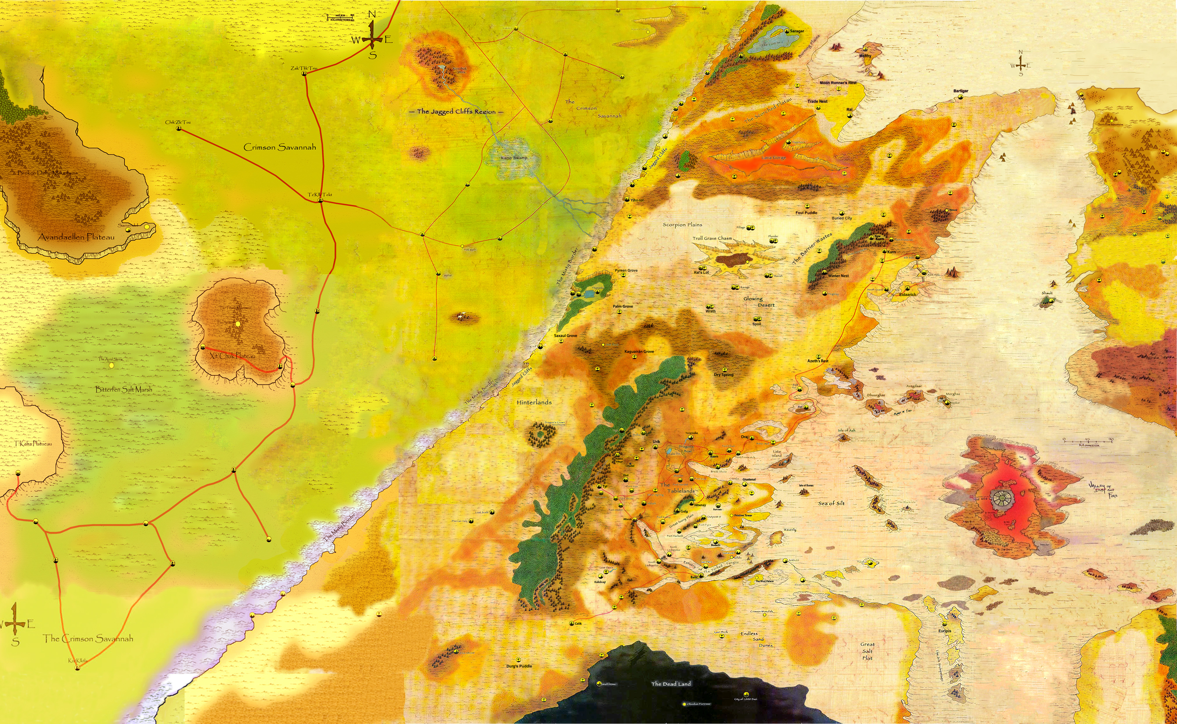
It’s also mentioned that certain areas not too much further north of Urik (the Glowing Wastes) get extremely cold at night in comparison to the Tablelands proper. Now, that’s without the Ringing Mountains to stop some of the wind that would whip in from the West. I always thought of the map similar to California in RL, with the Ringing Mountains stopping all the moisture on the west side of the range. My thought was that somewhere far to the west off map there would have to be a larger body of water… or a reason for there to be more atmospheric humidity.
1 Like
Amazing work guys in putting this all together!
I’ve been spending a lot of time digging for resources out there to fill in the missing gaps from the Athasian Cartographer’s guild, and recently I discovered areas which aren’t featured on his site. I’m looking at using their tools to add new maps to the page.
Anyone know how to get in touch with the guys at the Athasian Cartographer’s Guild so I can add these maps? He isn’t responding to emails…
Hey guys.
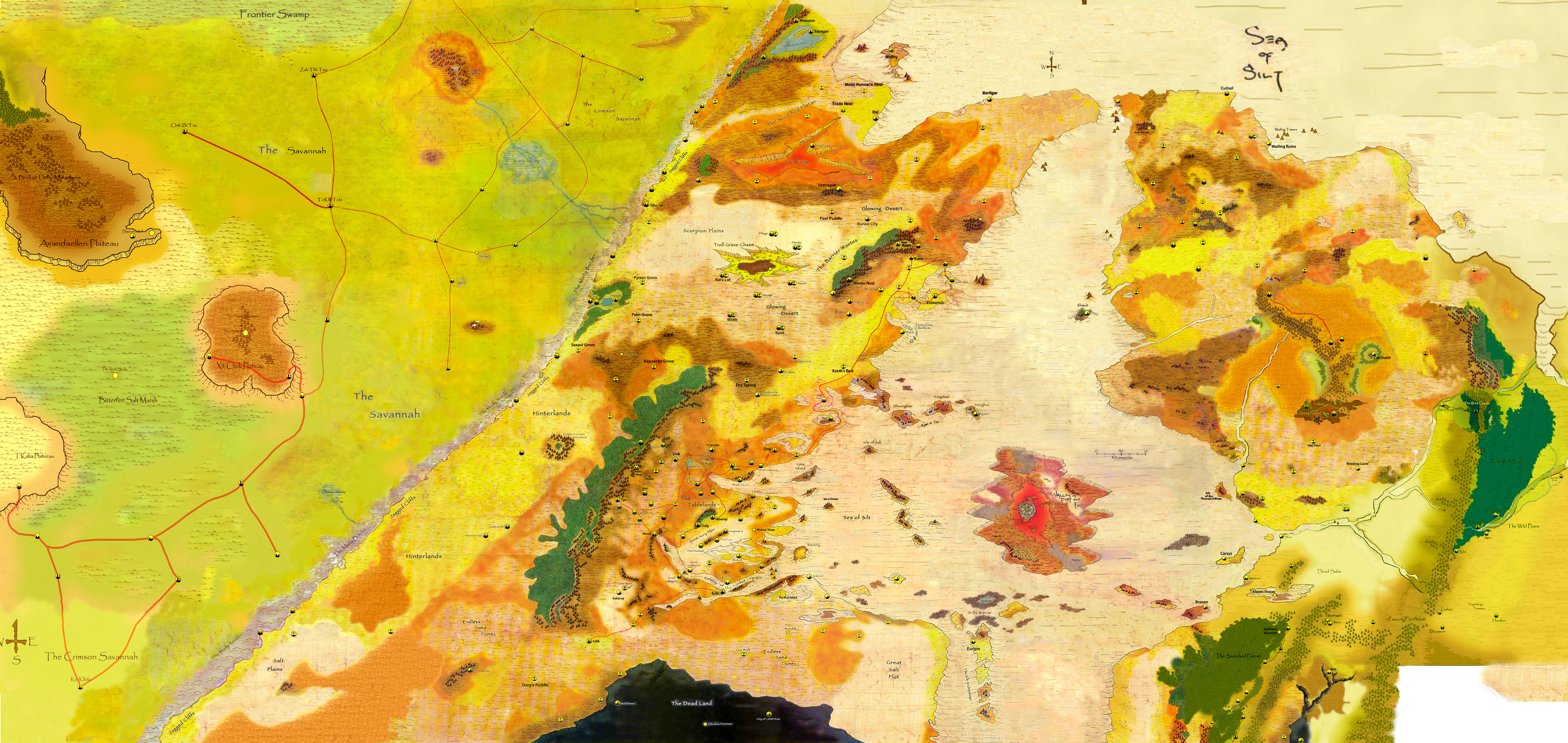
I did find this map as well, which improves upon the Digital Wanderer’s map by adding a bit more to the east and west. It also corresponds nicely with just about every other map I’ve seen to date.
Annoyingly I cannot find the original source again. I’ll let you know when I discover it.
3 Likes
Nice, thanks for sharing
2 Likes
[quote=“Garolnemay_Montego, post:25, topic:497”]
Hi everyone and neujacck,
I am the original source  but I just put together all the maps from original resources and maps from Athasian Cartographer’s Guild http://ds.daegmorgan.net/
I’ve expanded to the west and improve a new full version of this one.
Although the work is still in progress.
9 Likes
Great work Garolnemay!
3 Likes
Awesome work. Thank you!
3 Likes
This is amazing Jhonny! Thank you again.
I was about to comment that you should add in The Sundered Regions, but then I noticed that you already did. I was expecting them to be smaller than they are. I can see how tricky it must’ve been to get those two maps reconciled. Well played!
If only we could get access to the code at http://www.digitalwanderer.net/darksun/ and update the map he’s using with this one…
2 Likes
The Sundered Regions are there but very spread out. Cool none the less.
2 Likes
That’s really great work, and just the kind of thing I was hoping could be organized in an earlier thread I started. I wonder if we can expand this to include the rest of the continent. I think the first priority would be to include all of the kingdoms mentioned in the deadlands document that was recently released, which would involve expanding the map southward.
What program(s) are you using?
2 Likes
Hey @Sysane
Thanks for your awesome creativity for the Sundered Regions. I’ve just noticed you are the author of this great map.
In this version I took from you a lot of stunning ideas. My favorite is The Dark Copula. In my campaign is a protective copula created by a circle of druids originally to guard this piece of land form the sun and the rampage of the Dragon when Borys was transformed in the Pristine Tower. The Rampage took Boris to the east and almost obliterate every city (without the protection of a SK’s in contrast with the west well protected).
2 Likes
Hey @Sebastian_Grove!
Thanks!! Responding your idea I would say yes. But is a lot of work for me. I have to spend a lot time although I am getting skill in Photoshop the main problem is the time I have to invest.
The program I am using the most is Photoshop.
1 Like
I tried to stitch some of these maps together myself, and they’re not consistent in the size of the mountains and other features, and sometimes the borders and roads don’t exactly match up, so I appreciate what a challenge it is. I also tried throwing a couple into a hex map generator, but I’d need to find versions that didn’t have the city’s and labels on them to make a nice clean map.
3 Likes
Hey Jhonny:
Maybe the solution here is to just focus on one area at a time based on the information we have.
If you haven’t already seen, we’re in the process of trying to get the Dead Lands information reconciled:
Would you like to help us with the map?
How much bigger is the deadlands than what is depicted in maps included with the revised 2e box set? (Is what is shown most of it, a half, a tenth, a hundredth?)
The boxed set only shows the northern most edge. So I’d say it’s at least 10-20x the size shown in that map.
That would be my inclination too – the 2e document that was recently released on this forum describes several complex polities of the dead which each encompass several large conurbations. Each of these possesses cyclopean monoliths of various sorts. I would imagine a civilization of the dead on this scale would encompass something like the area of the Tablelands.
3 Likes
I agree. Judging from The Athasian Cartographer’s Guild, as well as the other “Dead Lands of Athas” supplement by Gerald Lewis, I would estimate our area of interest is about half again larger in both directions than the Tyr Region Tablelands map from the original Dark Sun Boxed Set.
If we were to compare it to the map you just posted, I would very roughly estimate the width would equal to distance between the west edge of the Valley of Dust and Fire to the western edge of your map, and the height would be equal roughly to the distance between the Obsidian Fortress and the top of the Troll Grave Chasm. While there is a lot of black there, it does wind a bit across the map. Personally, I think the Cartographer’s Guild made this area a bit too big to be any fun for game purposes. Besides, it’s kind of a creative cop out to make this as big as the rest of the known world put together.
I’ve made a development folder, where I’ve taken the Cartographer’s Guild maps, and made a composite on their unrolled planetary map of all the known maps we have, so that gives us some idea of the layout. Have a look if you like.
Does that help? Drop me a message if you’re willing to discuss. I teach Photoshop and Illustrator, so I might be able to help make this a bit easier for you:
1 Like
I have worldographer, which can trace hexmaps out of blank maps. I’ve been experimenting with it over the last few months – I’d be interested to try to convert some of this material into large hexmaps if I can get decent blank versions to work from.
Update: I’m having difficulties with the psd. format – the online platforms won’t open files this big; is there anyway you can make all these files pngs? I see that some of them are.
To give you an example of what I’m thinking about, here’s a first run at converting the region around the tablelands from the world map: hexmap tablelands
1 Like
Okay. That’s an interesting idea. So you’re looking for a way to do a larger conversion based on the maps we have?
I still think it will need to be refined and drawn. But I’ll see if I can get you another conversion.
What format do you need? Can you send me a sample of what you need?