If you have Adobe then it’s just a matter of making brushes I think. On the Athasian cartographers guild I think there were some tutorials.
Also the guys at the pristine Tower dev group have recreated all of the symbols and everything in vector programs I’m sure they can export it if you need them as raster.
Necroposting my own comment here, but I would be super curious, if someone who were much better than me at geopositioning. If we have one tower at the known PT location east of Nibenay. And if we had 8 towers at equidistant cubic points on the globe, where would those towers land if we used the DS Digital Wanderer globe map?
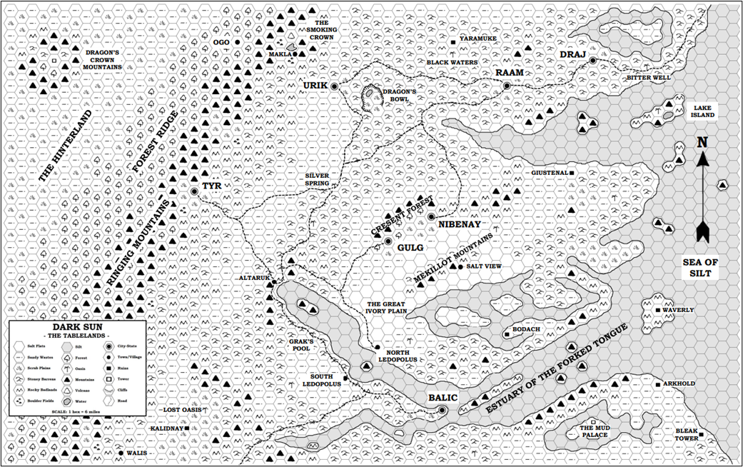
I created this (D&D Basic and Expert stylized) map as part of a larger project. It’s not the best resolution, but feel free to download and use for your own campaign or game!
The Pristine Tower development group is currently working on it, I think the maps will be uploaded to the Athasian cartographer site when they are ready
I also love the plethora of details you’ve come up with for the Anattan continent. I’ll see how many of these we can port over to the ACG map when we get there.
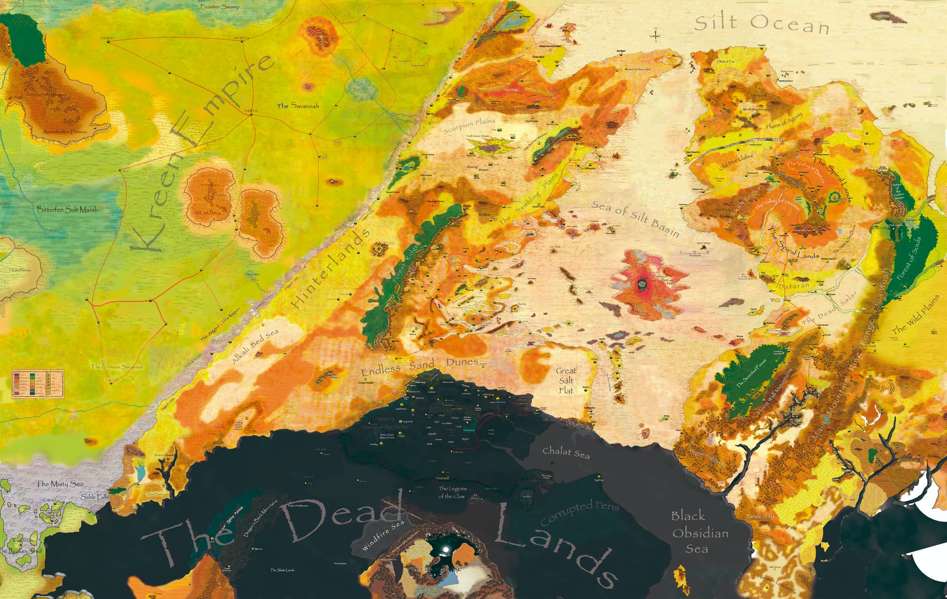
One question: What happened with your Dead Lands? It kind of looks like you missed most of the map info from both the Dead Lands boxed set and the ACG world map tiles we’ve released. As a result, none of your obsidian areas match any released book or upcoming book.
If you like, I’m happy to get you early access to the maps we have for the southern continent geography we’re using for the upcoming Frontiers of the Dead Lands book. In this book we’ve kind of defined the limits (or frontiers, if you will) of the entire Obsidian Plane and the Black Silt Sea.
Many Thanks Jack and thanks for all the people who apreciate my version of the map.
As we talked -sadly- Dead Lands and other features are far from being finished that’s why some areas are pretty messy. I’ll try to incorporate the information from boxed set and the ACG world map as soon as I can.
Talking about the southern frontiers of the Dead Lands I think I am not going to expand the map more than the measures that I am working on. It is too much for me for the moment.
What an excellent thread, and what wonderful maps.
Darkinterloper’s knowledge of some of the nebulous and opaque history of the Green Age is refreshing. It is an old chestnut, especially if we mean to pay respects as much as reasonably possible to each other’s various work over the years on the matter of Green Age history. Clues and details and littered throughout the original canon, and all the more so in the works we have created here.
Darkinterloper’s post here regarding human ethnicities and civilizational regions is interesting. The point I would like to make is that I find it impossible not to but conclude that several of the cultures of the Seven City-States were imported from outside the Tablelands. It is not believable that these alien-to-each-other cultures organically grew up next to each other. Specifically, Draj, Nibenay, Raam and especially Gulg are particularly alien to the general milieu of the Tablelands. We are even to take it that they tend to have quite noticeable human sub-race characteristics, and to be blunt, obviously evoke the Aztecs, Khmer, Mughal and Igbo-Nigerian physical and cultural traits. These cultures and peoples are very different to each other, or at least they are very different from the Balic=Athens and Tyr=Rome, etc. Mediterranean Europe backdrop. Happily, we have a ready explanation for this: these civilizations were forcibly transported by the retiring Champions when they at last concluded their world-wide campaigns of racial extermination. As I have discussed elsewhere, it does make sense that the Dragon would have ordered them to co-locate themselves to the same general region so that he might easier collect the Levy, and/or it may have been that the Tablelands survived better than almost all the rest of Athas, and they had no choice but to settle their armies in the Tablelands. This is not to say that the Champions necessarily natively belonged to any one of these cultures in an organic way (they were not born and raised in them), but they surely shaped whatever culture they adopted.
The Oba, for example, is portrayed in art and described by Denning as white with dark hair. Yet we suspect her people are largely blacks, with significant admixture of other human sub-races over the centuries. I would argue that in the course of her many centuries of crusading, her army may have at last devolved upon a culture resembling the warlike Igbo=Gulg people, and this being her last force and power base in some far off region, she marched them to the Crescent Forest and founded a city there.
Such explanations, anyhow, is how I resolve how so many very different cultures might be crammed into the Tablelands region, even if you x3 the scale.