Do it, brother! I would like you to host my content.
[WARNING: topic resurrection]
Seems like a really good idea @Grummore
Jack, is that composite graphic floating around anywhere else these days? The pCloud link doesn’t work anymore.
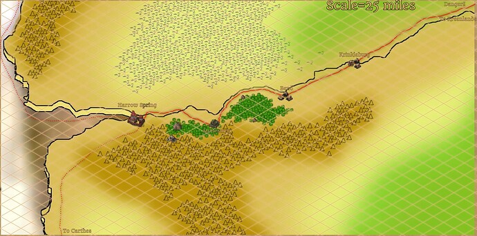
I have a map of the World’s Edge (B5 on the cartographer map), that I filled in with towns. The main city being Harrow Spring.
None of this area had settlements on the cartographer’s guild, so I filled it in myself to give me the perfect place to set my Ghosts of Saltmarsh conversion to Dark Sun. IF you want to use it I’m fine with it, but if you want to keep it blank that is fine too. I could also use fix it so the old Dark Sun symbols are used instead of the symbols I used. let me know.
Hi John:
Apologies, I removed it (I needed the space for my day job).
But I can add it back again to a different location.
@grummore - Do you have space for this load of maps, and if so how may I upload them for you?
Yes, I have space to upload things.
And I created this google folder for folks to upload things to, to save for the community. thanks for the great idea Grummore!
Feel Free to Add your own content to the uploads folder and we’ll organize it.
https://drive.google.com/drive/folders/0B-RGSGpu0zPiZjk0YWVkY2MtNTIzZS00M2I4LTllYWEtMDhmZWFkZmU3ZmFh?resourcekey=0-Xt749ANWowA1dyXRzAw3yA&usp=sharing
Brilliant. Thank you. What an amazing resource!
Once I’ve finished the planetary view map tweaks (and the Dead Lands map tweaks), I’ll pass over the folder as something like “planetary survey”.
I’ll try to reconcile as much developed content as I can into the big map, and it should by that point be calibrated to the distance measurements I’ve found as well.
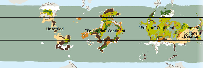
It’s still very far from what I’d consider presentable but I’ve been working on a Green-Age campaign map that is an amalgamation of pretty much every single piece of info, official or fan, I could find, mostly working to reconcile Brax’s and Brian Sanchez’s (Athasian Cartographers Guild) stuff. The recent release of stuff like the Wisdom of Sorrows and the worldbuilding stuff in Secrets of the Dead Lands and Lost Cities of the Trembling Plains have been fantastically helpful. Among my attempts to merge info:
-Per by own self-applied campaign rules nothing can be of an extraplanar origin and only the described Rebirth races are of Rhulisti stock (Human, Elf, Dwarf, Gnome, Orc, Goblin, Ogre, Giant, Pixies, and Wemics/Tauric,and Pterrans, Aaracokra, Kobolds, and Lizardfolk were former Nature Benders incapable of reproducing with the more ‘halfling-like’ races. Anything else is either an undiscovered species, mutant, lifeshaped, ect)
-Anattan and the Reman continent are one and the same, the ‘smaller but most temperate’ continent on Athas. The future Cauldron is the site of Reman itself, and most of the inhabitable continent is densely settled by humans, orcs, elves, dwarves, and Pterrans, with the Pterran’s civilization concentrated on the Sundra Peninsula. Sharn, Khormen, Braxon, and Marendol from the Anattan map were far-flung Reman coastal cities that were spared the volcanic apocalypse; the ‘thousands of feet of concreted ash’ Braxa describes is more concentrated in the east. The inhabitants of the Anattan cities and Suna Republic (arguably a successor to Reman) on the Sundra Peninsula are half-elves to match Brax’s info on post-Rajaat Reman, though Faye’Loryn are Half-Elves trying to preserve Elven culture. A surprising amount of ancient Remans were human-elf-orc hybrids.
-Going by the info for Olnach in Secrets of the Dead Lands, the agricultural limit would end well north of the actual geographic south pole featured on Brian’s world map, I’ve been excusing that as some weird orbital feature of Athas resulting in the agricultural belt being much narrowly concentrated around its Equator, likewise, not all regions saw verdant growth after the end of the Blue Age and the far western continents were likely too desertified to be habitable to match Braxa’s ‘only three habitable continents.’
-The 'Equatorial Continent" was more sparsely settled than the others, home to a lot of Goblins and the ‘Mountain Men,’ Kel Tan, and proto-Draj. The first two were of Tanysh descent who crossed over on Reman ships, while the Kel Tan were originally Remans but evolved their own highly distinct culture. Most settled civilization was concentrated along the eastern coast toward the Pristine Continent, which traded with Brian Sanchez’s elves of the inland sea that became the Crimson Savannah. The giant Argonath statues Brian describes were made by Remans long before the inter-ethnic (I’m more emphasizing humans, elves, giants, dwarves, goblins, orcs, giants, and ogres are all basically the same thing, ie weird offshoots of Rhulisti) strife of the Rebirth races started. The continent and its richest metal deposits on the planet saw an economic boom during the Jihad and Cleansing Wars, but metalworking polluted and shriveled up the inland sea to the toxic morass it now is, with remnants of what little survives clinging to its edges.
-Dunswich was founded by Geshur, the same humans who settled Saragar.
-The ‘Storm Queen’ in Brian’s notes on Chuul Jungles is probably one and the same with the mysterious winged Hafling Avangion figure from the Church in Undertyr and the Hinterland ruins. (‘Iliandrim’)
- Pennarin’s Illithids, instead of a Rebirth race, were originally Remans who stumbled upon Rhulisti bio-experiments and got infected with proto-ceromorphs, they didn’t really emerge until the Cleansing Wars and ruin of Reman, which forced them to flee from the Hiramin Highlands (per Brian, they would be to the southeast of Faye’Loryn). -Gith, Githyanki and Githzerai are more humans who were somewhere along mutating into something like Dray or Dragons, giving them the reptilian aspects. Hej-Kin (former Dwarves), Anakores (who knows), and the other ‘reptilian’ mutants are likewise failed ‘pseudo-dragon’ things that went terrible wrong, produced by Rhulisti mutagens like the Pristine Tower, psionic energy, defiling, who knows what else, both intentional and environmental.
-I’m categorizing the Elves of Athas mostly between the ‘Ghost Elves’ (the Western Elves of Saragar and beyond the Jagged Cliffs, Ra’Gaelyn, Brian’s inland sea cities, ect) ‘Kurn Elves’ (any elves east of Saragar and the Jagged Cliffs, ancestors of pretty much every Dark Sun) and ‘Regal’ Elves (Reman Elves, functionally went extinct millenia ago along with Reman humans in favor of modern Half-Elven Remans).
-I’m preserving the Land Within the Wind/Feywild from 4E but its instead an artificial ‘mindscape’ on a grand scale, created by Elves and Pixies out of the Grey itself, and Eladrin are the Elven equivalent of Elan or Maenar. It allowed the Pixies of Vanarra and Elves to master stuff like pocket dimensions ala Imaskar in Forgotten Realms, with entire cities fit into citadels. By the Brown Age most of it has decayed and been reabsorbed into the Gray, while some areas like former Vanarra are very, very undead and corrupted.
-Any Tieflings and Devils/Demons are instead living psionic fragments of Daskinor’s personality.
Thanks so much for sharing this. I love the way you have put a lot of effort into combining extant canon/non-canon lore, mapping, write-ups into one whole that has formed your own campaign.
You mention Brax and Brian, both are known to me. But which exact documents/accessories from Brax are you talking about? And you mention Brian’s notes, I searched my archives but don’t think I have those. Do you know a place where those are still hosted?
I found Braxa’s info through Ur Braxa https://urbraxa.tripod.com/, which is mostly dead, but their info on Reman survived miraculously in the ‘Athasian Photography’ section, and Brian’s info is scattered across the wotc chat archive called ‘Athas Planetary and Cosmological View’
But I’m not sure all the pages are still accessible. I was able to get the first 9 or so and the last few.
This is some great work in this thread. I was also interested to look at the proposed Deadlands map which includes elemental-lord city states, which is an idea I’ve seen tossed around other places as well. I really gelled with the ‘Mysteries of Athas’ concept of just putting together lots of alternative visions of extra canonical lore. Like I could see assembling ideas for the dead gods of Athas, alternative versions of the history and other continents, etc. It is interesting that this proposed map seems to have become fairly widely accepted (I made an alternative world map myself, but I’ve never seen anything else proposed for a planet wide view). Is everyone completely satisfied with that, or are we just defaulting to it because it’s been floating around for so long and has been used by some many other projects? It seems like the Deadlands project is going to alter some of its elements, but is the apparent direction that the rest of it is basically going to be used, or are further changes still under consideration for future developments?
I’m personally very invested in the ‘planetary romance’ angle of the setting – I started with 2e – the revised campaign setting was one of the first DnD products I ever bought when I was like 9 years old. The halfling biotech is in the introductory adventure. I’m also intrigued by the concept that the Crimson Savannah is an ancient sea bed – that gets at the idea of the thri-kreen as stand ins for the green martians roaming the dry sea beds of Mars/Barsoom. I’ve even seen the idea proposed that most of the rest of the planet consists of these dried up sea beds and thri-kreen. In any event, I’d be super interested to imagine what exists beyond the Tablelands in a more comprehensive way, even if it’s just a serious of options instead of one canon everyone will use.
The maps on the athasian cartography site are certainly interesting and are an impressive attempt to imitate the original style – but they’re also incomplete and don’t line up completely with each other or with the originals (the mountains are different sizes, some of the areas’ borders don’t match up). I think it’d be awesome to try to make some resources which were a complete, systematic, same-style, larger picture of the planet that incorporates all this material, but isn’t in several slightly different styles, includes the new Deadlands stuff, etc. I’d also like a pony.
I use worldographer for my homebrew maps, and I’m not good enough with GIMP or acrobat or anything like that. I toyed with a version of the Drake’s tail peninsula from the athasian cartography site and recreated it in worldographer using it’s tracing function. It’s easy to make a hex map that looks like the imagined area using the convert underlay function, but if you drill down to the details a lot of the individual hexes will have odd choices because the program is trying to match the color palette of the original and it’s not a perfect translation between individual features and the the hexes it uses to represent those colors. I can try to post some examples if anyone’s interested.
I could slowly the main continent into big hex maps like this that would all have the same style (with the limitations I noted). It might be interesting to try to combine the notes in that Wizard’s thread with some crowdsourced ideas – like each region could have about 100 bullet points as ideas (e.g., Plain of Zak’thask – psionic crystal hivemind entity that pierces an arid plane, inhabited by elf variants who all have parasitic crystal entities living in a symbiotic relationship with them).
Hey there.
Speaking as the chap who has been responsible for some of the shake-ups to the Dead Lands map and southern continent over the past year, as well as the person who made that new Dead Lands and southern continent map (Development Discussion for Dead Lands - #20 by neujack), the reason why I’ve done this was to fill the gaping hole in the map left by the Cartographer’s Guild due to simply not having the information.
The only part of this map that is set right now is the red box, which is in the upcoming Dead Lands book. The rest I included in an effort to contain the blackglass. And all those other areas are open to development and detailing by whomever feels up to the task. 
I wanted to give you all something to play with surrounding the lands, and there are even some sections of the obsidian plain which haven’t been detailed yet. So we’re open to ideas…
Do you have a bigger, higher-res version of this? I can try to turn it into one or more big hex maps with a bigger file – the program’s output in terms of it’s fidelity is pretty closely linked to how good the original image you’re working with is. Bigger images pick up a lot more detail in worldograper
I don’t think it’s a bad fix at all – I was just interested because I think the other proposal for that kind of area was the Drake Dominions on the far western side of the continent. Of course, there could be two such areas – one could be oriented towards the paraelements, or one could be ruled by elemental lords and the other priests, or one could have some kind of elemental civil war going on – the options are really endless aren’t they? The setup you have leaves a lot of interesting possibilities for wars between the bugdead and the elementalists.
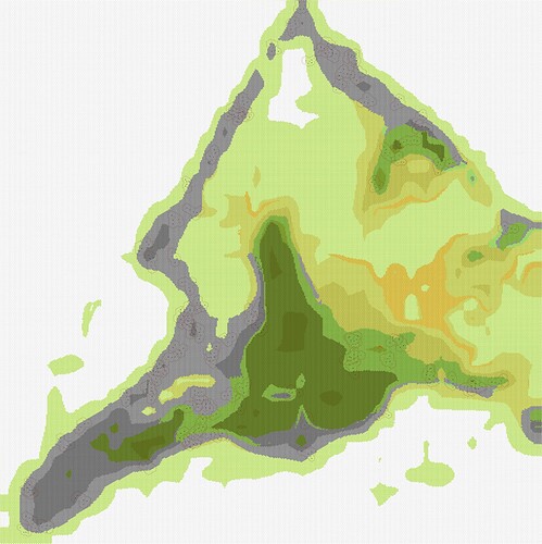
Here’s an attempt at a section of Green Age athas as a hex map
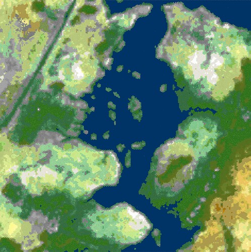
Here’s another attempt: https://files.catbox.moe/5txskd.png (this will load slowly – you’ll notice the program tries to reflect the labels a little, so it’s really necessary to have an unmarked map to get the best results)
The source image is plenty large (36600 by 12400 currently lol) but I still have a lot of work to do on it, like adding the new revised ulyan/dead lands, fixing colors, ect
If you’re improving the world map in our neck of the woods, I’d be interested to see what you come up with…
oh no just incorporating your new take on the dead lands into my map, I was using the older variant from higher up in this thread. I like how you also put a former lake in that far western extent of the obsidian plain lol
I stuck Ythri/Zethri up where ‘Reaver’s Reach’ is on that chunk of the Hinterlands/Tablelands above the Misty Sea and Ulyan, was going with the notion that Ythri was destroyed in ages past by the Tanysh as they pushed south and raided cities like Lizardfolk Celik, the ruins were resettled and renamed ‘Zethri’ which became the center of Tanysh culture in the far south. Working off the info from Wisdom of Sorrow I’m having it so Kadiran Firehand (the statue in Yaramuke in ‘Black Flames’) was the first King of the Tanysh, who conquered Malai cities like Yaramuke, Nibenay, and Raam, and pushed south, but the Tanysh Empire collapsed very swiftly into many independent kingdoms, city states, and tribes.
If taking the info that Giustenal is over 12,000 years old at face value, the rise and fall of a unified Tanysh and the return of Remans to their mother continent had to have happened in the immediate 2,000 years after the end of the Blue Age. Going by the timeline in Lost Cities of the Trembling Plains humans went from living in caves to founding Tanys in only 88 years.
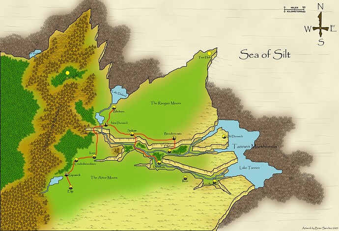
An attempt to expand on Brian Sanchez’s Dunswich:
The Northern Canyonlands
North of Saragar, the Burning Plains give way to more traditional scrubland, which continues, largely featureless, northward. Along the eastern coast of the silt sea, the land gradually juts upward to heights rivaling the jagged cliffs, at nearly two miles- on the plains, however, this incline is gradual. Along the west, the Jagged Cliffs rise nearly 4 miles above the Crimson Savannah, eventually merging into the insurmountable Ironcrags. The further north one travels, the cooler the temperature becomes, and the scrubland gives way to actual grasses, and expanses of heath and small bogs. This northern part of the continent is in fact a massive highland located along a rise of the continental shelf, rising miles above the old sapphire sea and crimson Savannah. While not high enough to experience snowfall, runoff from the Ironcrags fosters a cooler, dry climate- the shelf was once covered in lush, cold forests, but desiccation, defiling, and felling has reduced the woods to the foothills of the Ironcrags. The Canyonlands owe their relative lushness to the insurmountable Ironcrags,: as high-altitude moisture and cold air off the Sea of Winds hits the peaks, it results in massive lightning storms and torrential rainfall that water both western and eastern sides of the mountains. Three major rivers, the Artor, Deland, and Tannen, flow through the region at a strong pace, albeit reduced from the Green Age. The Tannen River cascades into a 2-mile deep crater filled with mist, full of verdant land and forests, before flowing into the Sea of Silt, pooling into Tannen Lake, which is surrounded by thick mudflats and marshlands. To the north, the Deland River splits from the Tannen, pooling into upper Lake Deland, and dramatically cascading two miles down into the silt of silt, pooling into lower Lake Deland, which is also surrounded by thick mutflats and marshes where the water meets the silt. The third river, the Artor, flows north from the ironcrags, pooling into Lake Artor. The continental rise of the region is split into four plateaus covered by dry moor and heath, with the massive Tannen Canyon dividing them from each other.
The Artor Moor
The scrub plains north of Saragar eventually give way to moorland, sustained by the cooler climate and higher elevation. While lush compared to the southern scrublands, the acidic soil makes it unsuitable for agriculture. The Moors are no less dangerous than other Athasian verdant climates- numerous types of predatory or parasitic algae, lichens, mosses, and oozes thrive in the acidic, relatively cool and damp environment, as well as many of Athas’ few surviving amphibians. The moor itself is sparsely populated by humans and demihumans. The southernmost settlement is Elgy, a border fort guarding the southern border of the town of Gipswich. The fort is named as such for the freshwater eels (actually cousins of Cistern Fiends) that infest Lake Artor. In addition to being a delicacy, they also function as personal water purifiers if allowed to live in water pots and basins, and are one of the region’s most valuable exports. The region around Lake Artor and Gipswich are known as the Fens due to being well-watered by runoff from the Ironcrags, creating the region’s main belt of arable land. This belt stretches north as far as Blieburc. Cool rain forests rise along the foothills of the Ironcrags to the east. The largest town in the southern fens is Gipswich, which, like other Dunswich settlements, is a strange translation of Saragar-esque Green Age systems into a modern bronze-age context.
An elected council of the Wich, or Trading Center, Bailiffs (the equivalent of Lawkeeper) representing the town clans, govern day to day affairs, and sending representatives to serve on the Reeve (Lawmaker) Council in Dunswich. Most buildings in Gipswic, lacking stone or even reliable mudbrick, build earthen and wood structures, with peat and reeds sometimes used as an alternative. Gipswich is located on the shore of Lake Artor and exports fish, lumber, and other goods. Numerous dwindling iron, gold, copper, and tin mines dot the Ironcrag foothills. The road north passes through the village of Cnobsheresburc, a lumber town, and Iceni, a fort that protects copper and tin mines along the southern rim of Tannen Canyon. The road travels north before meeting the narrow western end of Tannen Canyon. Crossing the span is a wonder of engineering, the Great Gondola. Built across remnants of a sophisticated ancient Green Age transportation grid, the Gondola is made of extremely resilient rain-forest vines and wood, which do require maintenance and replacement every few decades. Teams of Mellikots on either side draw an enclosed wooden cabin across the span along a cable- while the process is stunning and nerve-wracking, it is mostly safe, as the Mellikots are well trained and the materials of quality. And thankfully, the mists and clouds conceal any wreckage down far below. The gondolas pass by the magnificent sight of the Tannen River cascading down over 10,000 feet in a massive waterfall to the valley below.
The Raegain Moor
While a bit cooler than the Artor Moor, the Raegain is generally similar. Billows of cool air rising from Tannen Canyon fall down along the southern rim, granting enough precipitation to make the moors arable. The Raegain Fens mirror the Tannen Fens down south, providing a belt of arable land along the banks of upper Lake Deland and the Deland River. The trade road runs north of New Dunswich to the village of Blieburc, which relies on fishing and offer travel down the sheer cliff alongside the 10,000 foot cascading waterfall, down to the Deland Marshlands below. Shrouded in silt haze and mist, these dangerous mudflats and marshes are oddly silent, still carrying the taint of the ancient Blight that ravaged Dunswich. Travelling east along the arable northern edge of Tannen Canyon, the trade road passes through the village of Soham, to the town of Beodericswic. The town, similarly to Gipswic, is run by a council of clan-Sheriffs, and exports chalk mines from the cliffsides, as well as truly precious commodity- hops. Two trails cuts through the white cliffside of northern Tannen Canyon, with numerous outposts and storehouses built into caves and carved structures. These support numerous wooden and vine elevators used to haul large goods or creatures, slowly, up the cliffside. Far north, at a ruined fortress called Tun Hoh, the treasures of ancient Dunwich monarchs are said to be hidden, and guarded by fierce, shadowy undead.
New Dunswich
For millennia, the lands around old Dunswich were afflicted by the Blight, perhaps the work of the Cleansing Armies, or a final revenge of the Elves against Albeorn’s home city. Any small animal life instantly shriveled and died, and intelligent beings slowly grew sick and wasted away from some magical illness, but plant life was unaffected. Eventually even the lush northern forests withered away as the planet desertified, and intelligent life only survived clinging to the foothills of the ironcrags. But water still fell in abundance from the peaks, and through means perhaps magical, perhaps mundane, over the millennia, the rivers and rains washed away the Blight over the cliffs and into the silt and mud below. For centuries, as humans and others resettled the moors, society was dominated by warring feudal clans until their unification under a warlord who reorganized the clans under a pseudo-democratic system loosely based on the Green-Age system of Saragar. Some have said the great monarch actually came from the forbidden southern city. They established a new capital along the Deland River, naming it ‘New Dunswich’ in honor of the ancient Green Age port metropolis.
New Dunswich should be a thriving city; isolated from the deserts of the south by hundreds of miles of plains, located high above the worst effects of Athas’ defilement. It is a rare sight on Athas, a town of wood. The rich lumber of the eastern rain forests, the sort of ancient trees that thrived during the blue age, lasts for centuries, allowing new Dunwich to look more like a cheerful green age city than a mud-brick den of desperation baking in the sun. New Dunswich appears as a classical medieval town, like those bright villages of the Marnita Valley, with colorful roofs and solid construction, but there is a rot afflicting the city. The buildings seem to sag in on themselves, the townsfolk are a paranoid and secretive lot, things move in the corner of one’s eye and geometry feels off. Shadows stretch longer than they should and the life giving rains from the Ironcrags are unnaturally long and cold. This malaise seems to affect the entire land, and indeed it does, brought by an ancient curse linked to a dread son of Dunswich, Albeorn, now known as Andropinis, the Sorcerer-King of Balic. While trapped in the Black, Albeorn explored its darkest depths, and what lurked there terrified even him: squiggling things in the void between the stars, warped geometries, a Far Realm beyond even the ken of the undead and shadowy horrors of the plane. Albeorn escaped his imprisonment via a circuitous route of mindscapes and demiplanes, and something followed him back. While he arrived back in Balic, it, perhaps piggybacking on his memories, arrived in Dunswich, his ancient home. New Dunswich is a settlement of around 10,000, surrounded by high earthwork-and wood walls, and a port on the upper lake Deland. Its primary industries are beer production, sugar refinement from the eastern forests, lumber, and metallurgy, specifically smelting copper and tin into bronze.
Tannen Canyon
During the Green Age, the bottom of Tannen Canyon was filled by the Sea, but as the sea turned to silt, the inlet tried up. Over the millennia the flow of the Tannen River beat out the Silt, turning it into rich mud, and eventually life began to blossom, first scrub and grasses, then trees. While much warmer than the above moors, the valley is still quite pleasant, cooled by constant mist streaming up from the waterfalls and the shade provided by the narrow cliff walls. In addition to the great Tannen Waterfall, many smaller falls from aquifers under the moors spill out, turning the Tannen into a roaring beast at the Valley bottom, fed by numerous tributaries. The Tannen Canyon bottom has been cleansed of the lingering Blight by the constant waterflow, and as a result is some of the richest farmland in the region, and hosts several small villages: Elmham, known for its waterwheels and mills; Derehame, known for its beermaking and woodcraft; and Rendlesham, found on the edge of the great Lake Tannen and its mudflats. Rendlesham often provides services for travelers exploring the Tannen Marshlands. The base and cliffsides are heavily mined for copper and tin, the lifeblood of Dunswich, as bronze plowshares are required to farm in the fenlands.
Lowland Vale
A cool, misty valley located to the northwest of Dunswich, the Lowland Vale is a sparsely populated, densely forested valley encircled by the Ironcrags. A few small villages grow the precious plant known as Sugar and harvest rainforest plants for medicines to export to Dunswich. Most notably, a hidden mountain pass crosses the Ironcrags, into the depths of the Chuul Jungles.
Old Dunswich
Isolated on a broken plateau in the middle of Tannen Canyon, amid dry scrubland and moor, are the stone ruins of the great Green Age city of Dunswich. Founded by the Geahur people who also founded Saragar. the city was known as a great port, but largely isolated from affairs to the south, mostly trading with its mother city and the ports of Bartigar. east of Saragat, and Erasat on the Gray Isles. Dunswich frequently competed with the Ghost Elves of the west for control of the northern seas, and their rivalry colored the worldview of a young man born in the city during the Preserver Jihad, Albeorn. Albeorn eventually left for the south and never returned, and the Preserver Jihad seemed a distant squabble to the people of Dunswich. Even as Saragar cut itself off, the people of Dunsiwch seemed safe from the chaos to the distant south. Eventually the Cleansing Wars came north, as Elven counterattacks disrupted Dunswich trade and the city eventually died to a mysterious Blight that killed all animals but left the boreal forests healthy, if silent. Eventually the seas turned to silt and the forests receded, giving way to moors. and proved too acidic and dry to support crops. Survivors fled west to the fens and foothills of the Ironcrags, where their descendants clung to life for millennia onward.
Dunswich Geshur
The humans of Dunswich, like the inhabitants of Saragar and the inhabitants of the Gray Isles, are descended from the Geshur people of the Green Age, but tend to be shorter and broader than their cousins to the south, due to living on a high-elevation plateau. They tend to be ‘barrel-chested’ with higher lung capacity, and function well in the mountains that so cripple lowland Athasians. Conversely, they do badly in lowland desert. Dunswich residents speak a variant of the language spoken by those in Saragar, but after millennia the two peoples can only recognize certain shared words between their tongues. Dunswich culture is strongly influenced by the political structure of Green Age Saragar. Local villages are run by an elected mayor known as Sheriff, usually the clan leader, while larger settlements are run by a council of Bailiffs, local Clan leaders elected internally within the Clan. New Dunswich itself it run by a council of high Clan Representatives known as Reeves. While supposedly democratic, these elected roles are often dominated by the rich or landowners, or Clan favoritism. Residents of Dunswich favor very colorful dress, often unisex skirts/dresses or cloaks, and occasionally trousers and simple shoes when working. Unisex broad-brim hats and caps or fez are favored. Some Dunswich humans practice body modification and tattooing, including scarring and cranial deformation. Due to the region’s abundance of copper and tin, copper, bronze, or silver or gold for those of status, torcs are quite popular.
(Totally not blatently just the Kingdom of East Anglia with some Andean and Tibetan thrown in)
